Image

Murray-Darling catchment

The Murray–Darling Basin is the largest and most complex river system in Australia. It runs from Queensland, through New South Wales and the Australian Capital Territory, Victoria and South Australia, spanning 77,000 kilometres of rivers, many of which are connected.

Towns and rural communities across the Basin rely on a healthy river system—our economy, food security and well being depend on it, now and into the future.

https://www.mdba.gov.au/discover-basin


Please scroll down to comments below for further information, comments or latest news on climate and the basin.

Click on the heading to load if necessary

Image

weatherforum.com.au

A brand new Australian weather forum has opened… August 2019

as a replacement for the now defunct weatherzone forum .Weatherzone forum closed in JULY 2019 .

Paul Atkins is the author and administrator.

I go on there myself with username ‘crikey’

I encourage you to join and help build this forum with regular posts

Check it out here.. Its free.. Just register and start posting

https://www.weatherforum.com.au/Forum/

(Don’t forget the .au or you will end up in an overseas address.There are quite a few forums with a similar address)

front door


Pauls’ ABOUT page says

” WeatherForum.com.au forum is created and hosted by the same people who created OceanViewWeather.com.au and came about due to the closing of the WeatherZone forum in mid 2019. (Although we were a couple of months late!!!)

I am an IT manager, who feels the need to get back on the tools and play with things, like this forum, just to keep the old brain cells engaged!

We are a non commercial site created by a weather enthusiast for Weather enthusiasts.

We aim to create a forum where people can express their own opinions, however we expect users to respect other users as people and avoid conflict and trolling. To help with this we utilise various spam filters and profanity filters. This should help make the WeatherForum a place for young and old to enjoy.

(We is myself and Gemma the cat, who walked on the keyboard whilst the forum was being created)”

Rain trends vs -ENSO-IPO: Manilla NSW by surlybond

From 1999, rainfall at Manilla NSW matched ENSO only up to 2011, before the IPO became positive. This graphical log compares the rainfall at Manilla NSW with the El Niño-Southern Oscillation (ENSO) and the Inter-decadal Pacific Oscillation (IPO) through the 21st century to date. Values shown are anomalies, smoothed. (See Notes below on “Data”, “Smoothing”, […]

via 21-C Rain-ENSO-IPO: Line graphs — climate by surly

Image

Climate shifts…natural variation

I have started this blog post because today l have found out all major search engines are re routing the search string ‘climate shift’.

If you enter this term into any search engine, it will respond with pages and pages of ‘climate change’

We are being prevented from viewing alternative theories to man made climate change theories or facts, folks.

I will make an attempt to collect some links to climate regime shift sites that focus on natural variability.

I have tried alternatives to google and they ALL redirect the term ‘climate shift’

…You can get around this by..

Using google scholar…

which will accept the string ‘climate shift’ and lead you to alternative research on the reasons for global temperature trends other than AGW

or

on on the main google search engine page use talking marks on the search string which over rides the ban on the term… climate shift

“climate shift”


Image

Townsville and Brisbane. Past Rainfall correlated with sunspot number

This research was conducted by ‘RetiredWeatherMan ‘ a retired BOM meteorologist.

‘RWM’ is an active member of Australian weather forums

http://www.theaustralianweatherforum.com/forum/viewtopic.php?f=94&p=111657#p111657

…….

by retiredweatherman » Fri Aug 02, 2019 6:11 pm

The Queensland coastline from Bowen to Townsville has a more west-northwest orientation than the rest,
and even westerly in the Townsville region. The prevailing east-southeast trade winds therefore blow
more parallel to the coastline over this section producing lower rainfalls – the area being known as the
Dry Tropics. A range of hills from Cape Cleveland, northeast of Townsville runs to the south of
Townsville near Majors Creek, further protecting the Townsville region from the Trades. Therefore this
area is ideal to study for monsoonal influenced summer rains, with the monsoon flow being predominately
from the northeast to north. This region is also affected by PDO,ESNO,IOD and at the southern end of
MJO influences. And all these factors whether singly or in tandem can help to influence the rainfall
totals. As well as the coastline orientation, the lack of nearby coastal ranges largely negates rainfall
being boosted by the Trade Flow. My studies have shown these summer rainfalls may also be partly
influenced by the Solar Cycle in some instances, again whether singly or in tandem with other influences
as mentioned earlier. The attached graph shows the monsoonal summer rains, generally maximized between
November and April expressed as a percentage of the average of this 6 month period against the Solar Cycle
each year in January, back to reliable record gathering in 1872. For comparison is a similar graph for Brisbane
summer rain ( Dec to Mar ). Brisbane summer rainfall is more influenced by southern patterns then Townsville
therefore the similarities are not as well defined. One interesting parallel with the two sites is the very
long time it took to cast off the influence of the Federation Drought ( Brisbane more so than Townsville )
with the summer rainfall peaks moving generally upward roughly in line with the upwards movement of the
solar peaks from the Federation Drought period up to about 1960. The 2 graphs follow…..’


Image

Complete record of droughts at Manilla NSW from 1884.

By ‘surly bond’,an independent climate analyst at Manilla NSW , Australia.

Posted on ‘weather zone forum’ July 2019

http://forum.weatherzone.com.au/ubbthreads.php/topics/1502997/Re_NSW_rainfall_shortage_from_#Post1502997

Red colour marks times when rainfall was in the lowest one percent of occurrences. The graph is novel, in that the beginning of drought is marked as well as the end.

There were just six great droughts lasting more than one year: 1902, 1911, 1940, 1946, 1965, 2018.
Very long droughts persisted for forty years from 1910 to 1950, then they ceased for the next forty years.
The pattern does not match a model of climate change that supposes that droughts have been getting (a) more frequent or (b) more extreme.

Details are in posts such as:
https://climatebysurly.com/2019/06/08/rain-shortage-jan-2000-may-2019/

Image

2018/19 : the second-warmest financial year on record in Australia

Climate of the 2018–19 financial year ..Report by BOM

http://www.bom.gov.au/climate/updates/articles/a034.shtml2018–19 financial year

‘…it was the second-warmest financial year on record’

……

.My comment… Since when are ‘financial years’ the  time frame for the primary seasonal report?


Image

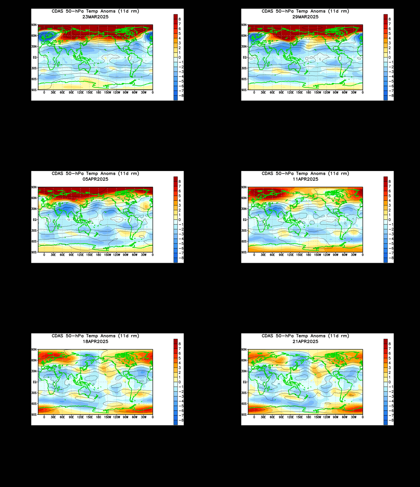
Stratospheric warming and a central polar vortex split in the Southern Hemisphere 2019

source

https://www.cpc.ncep.noaa.gov/products/intraseasonal

The above animation shows 2 warmings spots .. (edit.. sorry ONE warming spot , movinv west to east)at about latitude 60s commencing the first week of June 2019 .

They appear to be fully formed a few weeks later in the last week of June. The week of this post.

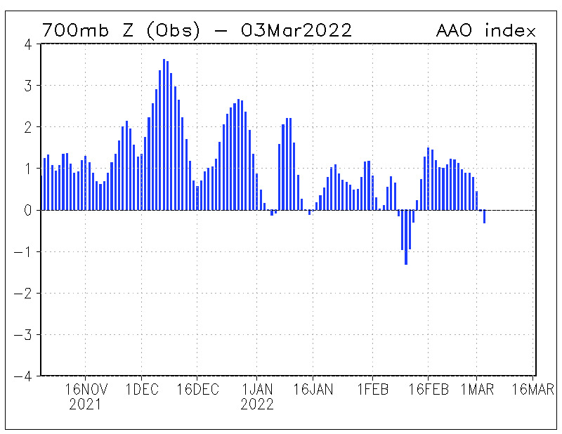
The AAO was positive during the month of June 2019 but is forecast by half the ensemble models to go strongly negative in the coming weeks.

I am not sure of the link between the Stratosphere warming and the AAO but will be on the look out.

—————–

This post is in progress. Check the comments section below for further entries. Click on the title of this post to load further information if necessary

Image

AAO correlated with southern hemisphere synoptic 2019

Here l take snaps of the ACCESS g model southern hemisphere synoptic and also record the AAO/SAM parameter.

Looking for synoptic patterns and if they correlate with shifts in the AAO. I will make a few observation notes as warranted.

AAO link.

https://www.cpc.ncep.noaa.gov/products/precip/CWlink/daily_ao_index/aao/aao_index.html

ACC g  southern hemisphere synoptic

http://www.bom.gov.au/australia/charts/viewer/index.shtml?type=mslp-precip&tz=AEDT&area=SH&model=G&chartSubmit=Refresh+View

The first entry is below and then scroll down to comments section for all further additions. Click on the heading to load if necessary

5th may 2019 _AAO

image below 8th may 2019  AAO  going strong positive  Here +0.7 and going up

8th may 2019 polar low displaces cold air _SH

11th may 2019 aao vs SH synoptic

Image

Tornadoes in Australia

Past and present.
Sometimes misconstrued as can be microburst, which is an intense top down downburst from a front or storm cell

Here’s everything you need to know about tornadoes in Australia

https://www.abc.net.au/news/2018-10-12/everything-you-need-to-know-about-tornadoes-in-australia/10370602

_____________________________________________________________________

1st May 2019

Possible tornado in south west Victoria

Here is a snap of in coming complex low. Tropical infeed and  cold wrap around. Before the major band arrives in SW Victoria

‘Tornado’ rips through Lake Purrumbete Caravan Park in south-west Victoria

Roofs have been torn off buildings and thrown up to half a kilometre away by what is believed to have been a tornado that tore through parts of south-west Victoria.

Key points:

  • Lake Purrumbete Caravan Park, in Victoria’s south-west, bore the brunt of the weather event
  • An SES member described the scene as ‘horrific’ and the worst damage he had seen
  • There were only a handful of people staying at the caravan park, with minimal injuries reported

Emergency services were kept busy overnight as a storm left a trail of damage from Camperdown to Lake Purrumbete.

The Lake Purrumbete Caravan Park bore the brunt of the weather event.

Owner/manager John Clements said about 40 cabins at the park had been “completely demolished”, with about 20 more damaged.

Mr Clements said the park would be closed for several weeks.

“We’ll just rebuild,” he said. “We’ll get back on the horse,” he said..

“Definitely closed for at least a couple of weeks. But hopefully it will be quick clean-up.”

Camperdown SES controller Colin Brian said SES volunteers had to cut their way through half a dozen trees that had fallen onto roads to get to the park


Click on heading to load all further entries if required in the comment section below