Image

Murray-Darling catchment

The Murray–Darling Basin is the largest and most complex river system in Australia. It runs from Queensland, through New South Wales and the Australian Capital Territory, Victoria and South Australia, spanning 77,000 kilometres of rivers, many of which are connected.

Towns and rural communities across the Basin rely on a healthy river system—our economy, food security and well being depend on it, now and into the future.

https://www.mdba.gov.au/discover-basin


Please scroll down to comments below for further information, comments or latest news on climate and the basin.

Click on the heading to load if necessary

Image

Cross equatorial winds

Winds don’t always stay in the same hemisphere . They do cross over in places across the equator 0 deg latitude.In both directions

I am starting this topic thread to investigate the flow of major wind streams from the Southern Hemisphere: SH and into the Northern hemisphere: NH   and vice versa ….in all seasons if l have the time.

I will capture the wind streams using ACCESS G model by BOM Australia

Greater Asia View because l am interested in the flow over Australia and across the equator

http://www.bom.gov.au/australia/charts/viewer/index.shtml?type=windbarb&level=gradient&tz=AEDT&area=DRSMC&model=G&chartSubmit=Refresh+View

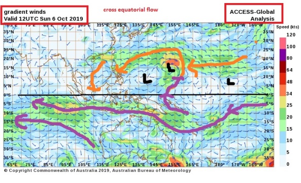
Here is my first snap below. 8th September 2019. The first week of the Australian spring.

Notice how the winds from the southern cooler latitudes are conveyed up to the warmer northern mid , sub tropical and tropical latitudes.

You can see the importance of the high pressure cells , in particular the eastern flank, in transporting the cooler surface air to cool down the north latitudes.

The flow doesn’t stop here but continues into the NH in possible favorite more common spots along the equatorial line.

7th sept 2019 wind pattern asiaoz


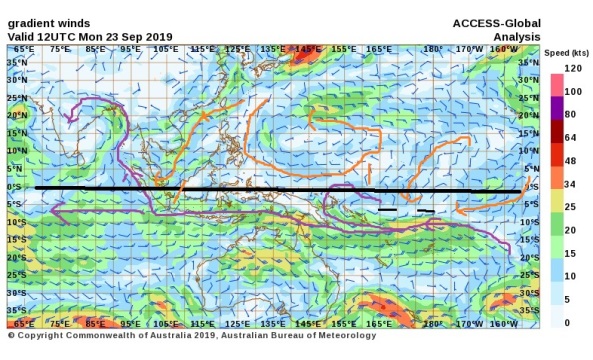
EQUINOX.. 23rd September 2019

There has been a significant change in direction of the NH wind streams this week. The major stream down past Korea  is on its way to the SH equator and some minor cross equatorial flow in the mid pacific atm

equinox 23rd sept 2019 wind asia


6thoct19 cross equatorial flow


Please go down to the comments section below for all further entries. Click on the heading to load if necessary.


Image

CYCLONE WATCH ………………. RESOURCES AND LINKS.

Some great links to  sites for cyclone watching and cyclone warning services

They are not listed alphabetically. Just scroll down

Please feel free to add in the comment section .

_______________________________________________________________________________________

CYCLOCANE

https://www.cyclocane.com/tropical-storm-risk/

_____________________________________________________________________________________

TROPICALTIDBITS

https://www.tropicaltidbits.com/storminfo/

_____________________________________________________________________________________

Image

Monsoon trough 2014_2015_2016

This continues from 2013 /2014
https://weathercycles.wordpress.com/category/cyclonestyphoonshurricanes/monsoon-trough/

————————————————

Please click on the title to load all further entries below

———————————————————————


The ITCZ ( intertropical convergence zone ) is surprisingly close to the equator for mid October 2014
Some healthy southerly flow down the west coast pacific bodes well for cross equatorial in N/west Australia as the season commences this November 2014
Also some very strong high pressure systems in the mid-Latitudes ( up to 1035 in the Bight mid October)

Some evidence of cyclogenesis along the equatorial line currently with2 cells in the SH

I like the look of this for some early activity..

picture source
http://www.bom.gov.au/australia/charts/viewer/index.shtml?type=windbarb&level=10m&tz=AEDT&area=DRSMC&model=G&chartSubmit=Refresh+View

Image

Monsoon trough ….Australia 2013 / 2014

THIS POST is a documentation of the monsoon trough in Australia for 2013/2014.. From November 2013 and in to April 2014
PLEASE CLICK ON THE TITLE TO LOAD ALL POSTS AND COMMENTS..FOUND ON THE BASE OF THIS PAGE

November 2013

The first signs of some cross equatorial flow from the northern hemisphere tropics across the equator and into the Northern Indian ocean.
The emergence of a monsoon trough line north west of AUSTRALIAN mainland inn the Indian ocean may bode well for an early cyclone development in the n/west of WA.
A tropical low has formed on the eastern boundary of this monsoon trough but is not being curently fed by the north east wind flow currently
A strong low pressure / troughing/ wet signal is current over the Australian mainland on the surface synoptic

monsoon trough nov 2013

CONTINUE DOWN TO COMMENTS SECTION FOR UPDATES.. CLICK ON THE TITLE OF THISPOST TO LOAD FURTHER ENTRIES