Image

New understanding of the drivers behind hot and dry conditions over Australia’s north-east

Posted by BCG on 14th March 2019

http://www.climatekelpie.com.au/index.php/2019/03/14/new-understanding-of-the-drivers-behind-hot-and-dry-conditions-over-australias-north-east/

Predicting temperature extremes and dry conditions over spring and summer is vital for agriculture, water supplies, bushfire risk and human health. But to make accurate predictions the Bureau of Meteorology needs to better understand the climate drivers behind such extremes.

Bureau researchers have recently identified how wind patterns in the stratosphere around Antarctica can drive hot and dry conditions over southern Queensland and northern New South Wales.

This research was undertaken by the Forewarned is Forearmed (FWFA) project, which is part of the Federal Government Rural R&D for Profit program. FWFA is supported by the Bureau, a range of Rural R&D Corporations, Universities and state government agencies.

While most weather systems like storms, rain and high pressure systems are found in the troposphere, the relatively turbulent first layer of the atmosphere, the stratosphere above it is known for its stable air flows. Commercial airplanes target this layer to find jet streams for a smooth and efficient flight.

A key feature of the stratospheric circulation is the development of the wintertime polar vortex, whereby Antarctic circumpolar westerly winds (extending up to 40-50 km altitude) seasonally strengthen from autumn to winter as the polar cap region seasonally cools. The vortex weakens and breaks down during late spring as the polar cap warms up. In some years the vortex warms up and breaks down early, which can lead to hot and dry conditions on Australia’s surface during late spring-summer.

The early weakening of the polar vortex results in a strong downward air flow and a lack of clouds over eastern Australia (Figure 1) via another large-scale circulation that Australian farmers already know – a negative Southern Annular Mode (SAM) according to Bureau researcher Dr Eun-Pa Lim.

“A negative SAM is responsible for bringing hot and dry conditions to eastern Australia in our warm seasons” says Dr Lim. “Anything we can do to improve our ability to predict SAM will help people on the land to prepare for and manage these conditions. The long time–scale of the polar vortex weakening, which spans several months, means if we can capture it in our model, we can potentially predict low SAM conditions during late spring as early as late winter.”

Figure 1. A strong weakening of the polar vortex and the associated negative Southern Annular Mode leads to an abnormally strong downward air flow and a lack of clouds (orange indicates less than average cloud cover) over eastern Australia, which results in higher than average temperatures and dry conditions. This plot shows the cloud cover variation in late spring-early summer following the early break down of the polar stratospheric vortex.

But just what is a polar vortex and how does it influence Australia’s climate?

The abnormal weakening of the polar vortex and its downward coupling in spring to summer can be visualised in Figure 2. During winter the westerly winds associated with the SH polar vortex are stronger than usual in the upper stratosphere (as shown in orange), which can allow more atmospheric waves to propagate from the lower atmosphere into the stratosphere. Because these vertically propagating waves act to weaken the upper stratospheric westerlies, the polar vortex starts to weaken from early spring. As the vortex weakens over time, the weakening signal descends (shown in blue). The impact is felt at ground level from October to January.

Figure 2. When the abnormal polar vortex weakening happens, generally the vortex is abnormally strong during winter (shown in orange) and then weakens rapidly in spring. The process of weakening of the westerly winds descends after September (blue). Exact timings of the strengthening of the winter polar vortex and its subsequent weakening in spring to early summer can vary year-to-year.  Wind (m/s) is measured as being stronger or weaker than the average.

Impact on Australia’s climate

Developing an index to measure polar vortex weakening and strengthening has been a vital part of the Bureau’s recent research and has made it possible for them to study the impact of these events on Australia’s seasonal conditions.

“The Bureau has developed the stratosphere-troposphere (S­‑T) coupled mode index to identify these events and quantify their strength,” says Dr Lim. The index is based on monthly average wind data (1979-2017) over the Antarctic sub-polar region (55° to 65° South) at all available vertical levels from the surface to 50km altitude.

The index allows the Bureau to measure whether the polar vortex weakening is progressing at its usual pace. A high index means unusual weakening which leads to faster vortex breakdown. The strongest weakening event occurred in 2002 (Figure 3), which was related to the strongly negative SAM in spring 2002 that is believed to have played a more important role in driving hot and dry conditions than the relatively weak El Niño observed in the same year.

Figure 3. The Bureau have developed the S-T coupled mode index to identify polar vortex weakening (in red) and strengthening (in blue) events. The strongest vortex weakening event on record occurred in 2002 (based on monthly average wind data from April 2002 to March 2003 compared to wind data of all years).

Hot conditions

The Bureau’s S-T coupled mode index also highlights other less dramatic, but still significant, polar vortex weakening/strengthening events. By comparing historic temperatures and rainfall for the October to January period with the index the Bureau have found a very strong correlation between the polar vortex weakening and hot and dry seasonal conditions in southern Queensland and northern NSW.

For instance, maximum temperatures (Tmax) in the nine polar vortex weakening years (Index ≥ 0.8) were 1.2°C to 1.8°C warmer over southern Queensland and northern NSW than in the other 29 years studied between 1979 and 2017 (Figure 4). At the same time rainfall was 0.4 to 1.2 mm per day lower; that’s around 12 to 36mm a month.

Figure 4. The October to January mean maximum daily temperature is between 1.2°C and 1.8°C warmer and rainfall is 0.4 to 1.2 mm/day lower over southern Queensland and northern NSW during the nine identified polar vortex weakening years than in all the other 29 years.

“When you consider the seven hottest years (the top 20 per cent) – they are over four times more likely to occur when it is a polar vortex weakening year than a non-weakening year,” says Dr Lim.

“The research demonstrates that the Antarctic polar vortex is an important driver of heat and rainfall extremes in subtropical eastern Australia during late spring to summer.”

“The Bureau’s new ACCESS-S seasonal forecast system has a high level of skill in predicting S-T coupling from the beginning of September, which will improve our ability to predict temperature and rainfall extremes for the spring and early summer in polar vortex weakening years,” she said.

This result of the Bureau’s research implies that if land managers can be warned in September that they are likely to face hot and dry conditions through to January due to the polar vortex weakening, it will put them in a better position to make timely decisions such as how to manage livestock numbers, pastures and their supply of supplementary feed.

Lastly, since the beginning of spring 2018 the stratospheric polar vortex has been stronger than usual, which is likely to have somewhat mitigated the hot and dry conditions promoted by the development of El Niño over Queensland and northern NSW. This was something we could be thankful for during the tough dry spring of 2018”

Eun-Pa Lim, 03 9669 4000, eun-pa.lim@bom.gov.au

Image

Climate shifts…natural variation

I have started this blog post because today l have found out all major search engines are re routing the search string ‘climate shift’.

If you enter this term into any search engine, it will respond with pages and pages of ‘climate change’

We are being prevented from viewing alternative theories to man made climate change theories or facts, folks.

I will make an attempt to collect some links to climate regime shift sites that focus on natural variability.

I have tried alternatives to google and they ALL redirect the term ‘climate shift’

…You can get around this by..

Using google scholar…

which will accept the string ‘climate shift’ and lead you to alternative research on the reasons for global temperature trends other than AGW

or

on on the main google search engine page use talking marks on the search string which over rides the ban on the term… climate shift

“climate shift”


Image

1998 Climate Shift

I was looking at some time series data in particular SH ozone and the AAO(SAM)

I noticed a clear and abrupt change around 1998 and onwards.

OZONE TIME SERIES

http://www.cpc.ncep.noaa.gov/products/CDB/Extratropics/figs5.shtml

ozone time zeries

AAO Time series

AAO time series1945 to 2011

1998 AAO climate shict


I thought l might check Google to see if researchers had documented a climate shift and the answer was yes.

There have been major climate shifts noted in 1925,1945,1975,1998

…………….

The Shifts Hypothesis – an alternative view of global climate change

source

The Shifts Hypothesis – an alternative view of global climate change

Guest post by Pavel Belolipetsky

( BTW..when  was searching for information on google for ‘climate shift’, l noted l got next to NOTHING..,It appears google have removed the term and given full priority to the term ‘climate change’.

I think l might change my search engine)

……..


Image

Troposphere height

Links , pictures, research, information.

troposphere rheemoclineatmosphere temperature layers with,height

In no specific order.

Theory. Height of the troposphere

http://www-das.uwyo.edu/~geerts/cwx/notes/chap01/tropo.html

extract

‘The height of the tropopause depends on the location, notably the latitude, as shown in the figure on the right (which shows annual mean conditions). It also depends on the season (1, 2). Thus, it is about 16 km high over Australia at year-end, and between 12 – 16 km at midyear, being lower at the higher latitudes. At latitudes above 60� , the tropopause is less than 9 -10 km above sea level; the lowest is less than 8 km high, above Antarctica and above Siberia and northern Canada in winter. The highest average tropopause is over the oceanic warm pool of the western equatorial Pacific, about 17.5 km high, and over Southeast Asia, during the summer monsoon, the tropopause occasionally peaks above 18 km. In other words, cold conditions lead to a lower tropopause, obviously because of less convection.

Deep convection (thunderstorms) in the Intertropical Convergence Zone, or over mid-latitude continents in summer, continuously push the tropopause upwards and as such deepen the troposphere. This is because thunderstorms mix the tropospheric air at a moist adiabatic lapse rate. In the upper troposphere, this lapse rate is essentially the same as the dry adiabatic rate of 10K/km. So a deepening by 1 km reduces the tropopause temperature by 10K. Therefore, in areas where (or at times when) the tropopause is exceptionally high, the tropopause temperature is also very low, sometimes below -80� C. Such low temperatures are not found anywhere else in the Earth’s atmosphere, at any level, except in the winter stratosphere over Antarctica.

On the other hand, colder regions have a lower tropopause, obviously because convective overturning is limited there, due to the negative radiation balance at the surface. In fact, convection is very rare in polar regions; most of the tropospheric mixing at middle and high latitudes is forced by frontal systems in which uplift is forced rather than spontaneous (convective). This explains the paradox that tropopause temperatures are lowest where the surface temperatures are highest.

The tropopause height does not gradually drop from low to high latitudes. Rather, it drops rapidly in the area of the subtropical and polar front jets (STJ and PFJ respectively in the Figure on the left), as shown in the Palmen-Newton model of the general circulation (Fig 12.16 or Fig on left). Especially when the jet is strong and the associated front at low levels intense, then the tropopause height drops suddenly across the jet stream. Sometimes the tropopause actually folds down to 500 hPa (5.5 km) and even lower, just behind a well-defined cold front. The subsided stratospheric air within such a tropopause fold (or in the less pronounced tropopause dip) is much warmer than the tropospheric air it replaces, at the same level, and this warm advection aloft (around 300 hPa) largely explains the movement of the frontal low (at the surface) into the cold airmass, a process called occlusion (Section 13.3) (4).


………

Google search.. ‘pictures tropopause height’

https://www.google.com/search?q=picture+tropopause+height&tbm=isch&source=univ&client=firefox-b-d&sa=X&ved=2ahUKEwjlnsDf-bDjAhVDfX0KHcEUAu0QsAR6BAgEEAE&biw=1025&bih=491

………..


Image

AAO correlated with southern hemisphere synoptic 2019

Here l take snaps of the ACCESS g model southern hemisphere synoptic and also record the AAO/SAM parameter.

Looking for synoptic patterns and if they correlate with shifts in the AAO. I will make a few observation notes as warranted.

AAO link.

https://www.cpc.ncep.noaa.gov/products/precip/CWlink/daily_ao_index/aao/aao_index.html

ACC g  southern hemisphere synoptic

http://www.bom.gov.au/australia/charts/viewer/index.shtml?type=mslp-precip&tz=AEDT&area=SH&model=G&chartSubmit=Refresh+View

The first entry is below and then scroll down to comments section for all further additions. Click on the heading to load if necessary

5th may 2019 _AAO

image below 8th may 2019  AAO  going strong positive  Here +0.7 and going up

8th may 2019 polar low displaces cold air _SH

11th may 2019 aao vs SH synoptic

Image

A study of cold fronts in Australia

I will collect information and observations

2019

Forecast for 532 thickness for Tasmania 6 days into Autumn. which can bring low level snow

low level snow tasmania 6th march 2019

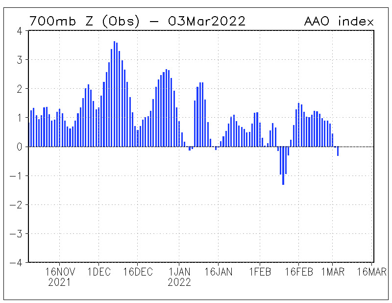
dynamic jetstream AAO negative 4_3_2019

ABOVE

Nothing like a wavy sub polar jet associated with a negative dip in the AAO/ SAM since —early February 2019, to produce dynamic wavy jetstreams at the 200hpa stratosphere.

and satellite picture BELOW ……………………….

is the cold pool in the Bight 5th March 2019. The day before it travails over Tasmania.

The cold pool sits within the bulge of the sub polar jet but at the surface layer

The cold air is transported north into NSW  by the southern  and eastern flank of the

Mid -latitude High

5_3_2019. cold pool ijn the bight

SOURCE. BOM

http://www.bom.gov.au/australia/charts/viewer/index.shtml?type=mslp-thick&tz=AEDT&area=Au&model=CG&chartSubmit=Refresh+View

__________________________________________________________

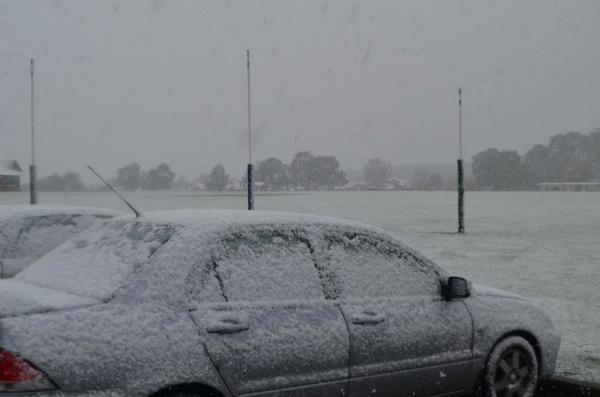
Temperatures got down to 9.8 deg in Hobart and light splatter of snow on Mount Wellington

Mount Baw baw in Gippsland Victoria also had a light dusting of snow with temps down to 0 deg c for most of the day

NEWS article

Mount Mawson 6th March 2019

quote from Ben ” 6th March 2019

Today’s taste of wintry weather comes less than a week after the state endured a day of record-breaking March heat.

Dover’s 40.1 degrees on Sunday was the first time on record any location in Tasmania has exceeded 40 degrees during March.

Eight other weather stations, including Hobart (39.1C), also beat Tasmania’s previous March maximum temperature record of 38.0 degrees on Sunday.

Impressively, Hobart’s 39.1 degrees on Sunday was also hotter than any day in the city during summer. Last season’s highest temperature was 37.9 degrees.

Sunday’s heat now seems like a distant memory, as much colder southwesterly winds flow over the state today.

Hobart was only sitting on 13 degrees at 10am, although wind chill was making it feel more like eight degrees.”

Image

Low level snow Australia

Click on the title to load all further entries at the base of this page

—————————————————————————————————————-

Records of past and present low altitude snow events below 600m , as l come across them

—————————————————————————————————————–

TASMANIA 1st August 2014

An extreme cold pool with thickness down to ~524 brought low level snow to Tasmania

Waratah at 600m

posted by’snowies’
“Most of the roads affected are in the west, generally 600m asl and above. Reports of slushy snow on the road at the Fern Tree Tavern (450m)”
waratah snow 60m 1st august 2014
about Waratah in the Nth of Tasmania
http://en.wikipedia.org/wiki/Waratah,_Tasmania
—————
Some snow reported at

Collinsvale (350m) near Hobart

Discussed here
http://forum.weatherzone.com.au/ubbthreads.php/topics/1271812/Re_What_s_happening_in_Tassie#Post1271812
——————
Gallery of pictures from the Mercury newspaper of the wild and wet weather
http://www.themercury.com.au/news/tasmania/photos-fnj4f7k1-1227009106102?page=3

MT WELLINGTON ( 1271m)

http://en.wikipedia.org/wiki/Mount_Wellington_(Tasmania)
“The snow-capped Wellington Range, as seen from the banks of the Huon River, at Franklin. Picture: Kim Eiszele”
1st August 2014
snow on mt wellington
—————–

31st JULY and 1st AUGUST 2014
VICTORIA

Thanks to KEN KATO for the sat pic’mage and here is where the event is discussed
“Today’s satellite imagery from NASA’s Terra and Aqua satellites looked truly spectacular”
sat pic 1st August 2014

Mt MACEDON 870m
“Nice 1cm snow cover here this morning. Down to -1 earlier now it’s -0.4C
…Just had another 20 mins of heavy wind blown snow, the temp dipped back below zero.
This is the coldest day I’ve seen here in the 11 years that I’ve been coming up to the mountain.
next day
“A Facebook friend just posted a pic of nice snow at or near Portland . It looks good .
We still have a full cover after a very cold night (-2.4C) it still below zero now. I’ve not seen it like this for years. It has been less than 1C for 40 hours now.
A fantastic event for us here, for a change !
3rd Aug 2014
“Still snow on the ground here this morning. A severe frost as well. It’s -3.4C”
4th August 2014
“Still snow on the ground here, if we keep getting frosts it will sit there in the shade for days.
-2C this morning and -6 again at Trentham.”
I’ve got pics on Facebook it’s Chris Williams Mt Macedon”.. by ‘avalan’
http://forum.weatherzone.com.au/ubbthreads.php/topics/1272165/6
———————–

“It also seems that Portland (NSW) indeed had some of the better clouds come over. smile Reports of 3 – 4 cm in parts” by ‘davem’
———————————————-
aussiestormfreak’ says”I’ve heard reports on Facebook of snowfalls in

Lorne and in the Otway Ranges


tempest’ says…”My brother texted to me a photo he has just taken above

Lorne – 250m above sea level blanket of snow on the ground!”

—————–
“Snowing heavily and settling here in

Ballarat

“.. says ‘newbury1’
Excellent photos and video from Ballarat here
http://www.news.com.au/travel/travel-ideas/snow-falls-in-ballarat-and-locals-wander-around-in-shorts-this-is-australias-toughest-city/story-e6frfqdr-1227010148241
St Patricks college Ballarat
snow ballarat august 2014
————————————
My neighbour told me snow was reported in Inverloch?
———————————–
Report from Katoomba
by ‘IPEX’
http://forum.weatherzone.com.au/ubbthreads.php/topics/1272243/Re_Snow_31_July_2_Aug#Post1272243
“Very fortunate to be in Katoomba over the weekend and experience quite a good snowfall during dinner at the Savoy in Katoomba St on Friday night. About halfway through the meal there was a sudden murmur of delight and excitement in the restaurant, and I looked up and saw it was snowing outside. Quite a few people (myself included) went outside to experience the flakes close up. It eased up within a few minutes but settled well on the cars in that short time.

Then 30-40 minutes later (wasn’t really watching the clock) it started snowing again – this time much harder and for longer. We were leaving the restaurant at this time and walking up to the Carrington, and were quite impressed with the downdrafts and amount of snow falling. This time, it was sticking to the ground and on plants, not just cars, and for a time, it was quite blizzard-like, with the trees in Carrington Park bending and swaying in the wind and snow blowing everywhere. smile Lots of snow on the ground the next morning (Hinkler Park on Warialda/Katoomba Street had impress snow-drifts – for some reason, there seemed to be more snow there than anywhere else) and patches of snow persisted in the shade all through Saturday. On Saturday night, there was still snow in the backyard at the B&B we were staying in!
—————

QUEENSTOWN in the sth island..For this event

A report from DaveM
“Out of interest, I saw photos of this latest event for Queenstown and a number of cm’s of snow all over the main street etc.
Fair effort at about 140 odd metres elevation!!
http://forum.weatherzone.com.au/ubbthreads.php/topics/1272370/Re_Snow_31_July_2_Aug#Post1272370
—————–

Image

Southern Hemisphere Annular Mode (SAM) Index..AAO

CLICK ON THE TITLE TO LOAD ALL FURTHER ENTRIES AT THE BASE OF THIS PAGE

SAM ( southern annular mode) Also referred to as the Antarctic Oscillation ( AAO )

TIME SERIES

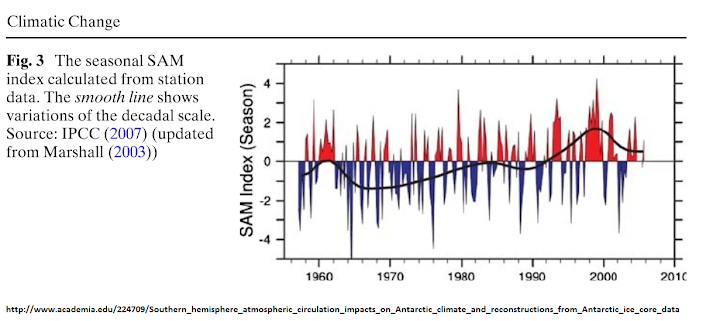
The SAM was trending positive from 1965 to 1999

SAM 1960 to 2010

SOME LINKS AND RESOURCES TO UNDERSTANDING THE SOUTHERN ANNULAR MODE
I will add to this list in the future
Feel free to post a comment on any information and links on the SAM.

TIME SERIES
http://www.cpc.ncep.noaa.gov/products/precip/CWlink/daily_ao_index/aao/month_aao_index.shtml
SAM time series

Of particular interest in the graph below …!!
is the hockey stick curve of positive SAM in the winter season data.

Since 2007/2008 the SAM has climbed ‘exponentially toward 2010.!!!

Notice this extreme positive phase is a seasonal anomaly for the SH winter period of JUNE/JULY/AUGUST.

In fact the summer and annual anomaly has levelled off or maybe even declined since 1998

1998 is considered as the maximum of the modern warm period by some cycle researchers.. Will the winter SAM start dipping negative as well?

Intuitively you would suspect a persistent negative SAM trend would be needed for a period of global cooling..?

…………The SAM index. SEASONAL..
Top.(.SUMMER. DJF 1947-2010)
Middle.( WINTER JJA ..1948-2010)
Bottom. (ANNUAL 1948-2010)

The yellow lines indicate 7-year Gaussian-type filtered values.
time series of SAM

RESOURCE LINK from
http://www.lasg.ac.cn/
Is There a Relationship between the SAM and Southwest Western …
http://www.lasg.ac.cn/UpLoadFiles/File/papers/2010/2010_JCLI_Feng_Li_Li.pdf

———————————————————————–

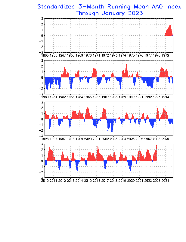
CURRENT SAM/AAO ANOMALY

http://www.cpc.ncep.noaa.gov/products/precip/CWlink/ENSO/verf/new.aao.shtml

CURRENT AAO index

———————————————————————

      • ‘SNOWMI’ on a NEW AUSTRALIAN FORUM has constructed a discussion thread titled

“Cold Front Activity Controls and Trends”

‘Snowmi’ has commenced discussion on the links to the SAM index and cold fronts across Australia

You can follow and join the discussion here
http://www.weather.liway.com/forums/viewtopic.php?f=6&t=4

You may have to register to view the discussion.
http://www.weather.liway.com/forums/index.php

This is a new weather and climate forum based in Australia since July 2013
The forum was developed as a result of the’ weatherzone forum’ closing its climate debate section which left contributors ‘short changed’ and bereft.
The owner of the forum ..’GB’..like myself felt a need to replace the hole that was left by the Weatherzone decision.
http://forum.weatherzone.com.au/

I thank ‘snowmi’ ( a moderator and contributor at the http://www.weather.liway.com forum)for posting the excellent link of the time series data for the SAM

—————————————————————————