I will collect information
Archive of MSLP .. Animated .. Time series
http://www.bom.gov.au/cgi-bin/charts/charts.browse.pl
Monthly anomalous MSLP – Australian region
MSLP ARCHIVES 2002 to current
FTP directory /anon/home/ncc/www/cmb/mslp/anomaly/month/colour/history/nat/ at ftp.bom.gov.au
ftp://ftp.bom.gov.au/anon/home/ncc/www/cmb/mslp/anomaly/month/colour/history/nat/
——————————————————————————————————
Thanks to ‘seabreeze’ for finding some mslp cells over 1040hpa
http://forum.weatherzone.com.au/ubbthreads.php/topics/1492673/58


2015/ 2016
“Pepler. Seasonal Climate Summary for summer 2015-16 . BOM
quote ”
with the mean January sea level pressure 3.8 hPa above average,
the highest January sea level pressure on record, .”
—————————————————————————————
Here is March.. average mslp
http://www.bom.gov.au/jsp/ncc/climate_averages/mean-sealevel-pressure/index.jsp?period=mar


Thanks to ‘one drop of weatherzone forum for finding this high mslp in summer of 2013 ( January)
1037 hpa over NZ
“The mslp archive shows a 1037 hpa going over NZ on 26th jan 2013
.It came up from the sub polar region.
The 1035hpa we have forecast this week( 1st march 2019) strengthens from 1028 in the bight to 1035 west of sth NZ from the normal west to east mid latitude high pressure belt flow
None the less
Ok. I have demolished my previous conceptions of high pressure mslp cells in the mid latitudes.”
forum link
http://forum.weatherzone.com.au/ubbthreads.php/topics/1492673/57
Thanks to EDDY G of weatherzone forum..
For this news article on High atmospheric pressure in June 20 ..2017
https://www.smh.com.au/environment/weather/remarkable-high-pressure-shielding-much-of-australia-from-winters-wrath-20170619-gwtqzo.html
and
weatherzone thread about very high mslp on 20th July 2005.. TITLED… VERY HIGH ATMOSPOHERIC PRESSURE
Some very amazing records for mslp .listed here as well
BOM climate summary for 2015/2016
“Pepler. Seasonal Climate Summary for summer 2015-16
quote ”
with the mean January sea level pressure 3.8 hPa above average,
the highest January sea level pressure on record, .”
”
Thanks KenKato from WZforum for this mslp map of Jan 2016
http://www.bom.gov.au/cgi-bin/climate/cmb.cgi?variable=mslp&area=nat&map=anomaly&time=history&steps=1
RECORD DRY IN MANY EAST COAST OF AUSTRALIA LOCATIONS
Here are some snaps of anomalous high pressure from the stagnant high in
NOV 2018
ftp://ftp.bom.gov.au/anon/home/ncc/www/cmb/mslp/anomaly/month/colour/history/nat/2018100120181031.gif
DEC 2018
ftp://ftp.bom.gov.au/anon/home/ncc/www/cmb/mslp/anomaly/month/colour/history/nat/2018110120181130.gif
JAN 2018
ftp://ftp.bom.gov.au/anon/home/ncc/www/cmb/mslp/anomaly/month/colour/history/nat/2018120120181231.gif
FEB 2019
ftp://ftp.bom.gov.au/anon/home/ncc/www/cmb/mslp/anomaly/month/colour/history/nat/2019010120190131.gif
link
ftp://ftp.bom.gov.au/anon/home/ncc/www/cmb/mslp/anomaly/month/colour/history/nat/2019010120190131.gif
—————————————————————-
High pressure in the Tasman , dried up the precipitable water in the TASMAN and so we had DRY south easterlies?
Even the onshore showers ceased in the sub tropics
Thanks to.colin maitland for this link and info’ and Blair Trewin
https://www.wunderground.com/blog/weatherhistorian/world-and-us-anticyclonic-high-barometric-pressure-records.html
copied and pasted below
World and U.S. Anti-cyclonic (High Barometric) Pressure Records
By: Christopher C. Burt, 9:18 PM GMT on November 26, 2011
World and U.S. Anti-cyclonic (High Barometric) Pressure Records
This blog is a follow up to my previous post on world barometric pressure records. In this case the highest rather than the lowest such. This post completes my recent series on pressure records.
World’s Highest Barometric Measurement
Believe it or not, this is a matter of some controversy. In fact, the WMO Extreme Weather Records Committee (chaired by Randy Cerveny of Arizona State University) is currently undertaking an investigation into this very topic.
The accepted figure for the world’s highest measured barometric pressure reading is 1083.3 mb (32.01”) at Agata, Russia (in Siberia) registered on December 31, 1968. Agata sits at an elevation of 855’ (261 meters) at 66° 53’N, 93° 28’E) on the Central Siberian Plateau. The weather at the time was clear and calm with a temperature range that day of -40°F to -58°F.
Sometime in the late 1990s a small commercial airport was built in the town of Tonsontsengel, Mongolia (48°45′23″N, 98°16′17″E) in Dzavhkan Province at an altitude of 5328’ (1624 meters). Like much of Mongolia the area has been experiencing a boom in natural resource extraction and a hydropower station was built on the banks of the Ider River that flows through this town of some 5,000 souls. Soon after the airport opened some remarkable barometric readings began to be reported from the airport, these pressure readings being, of course, for the sake of commercial aviation. On December 19, 2001 a reading of 1085.7 mb (32.06”) was recorded and then on December 29, 2004 the even higher figure of 1092.1 mb (32.25”) was apparently measured. Both of these figures, of course, would represent world records for high pressure. Furthermore, one may assume the figures were accurate since aircraft would not be able to use the airport in IFR conditions otherwise. The problem with the potential record pressure readings lies with the altitude of the site.
Tonsontsengel lies in a small basin in northern Mongolia at an altitude of 5328’ (1624m). It is possible that this is the location of the highest pressure (1092.1 mb) yet measured on earth. Photographer unknown.
When converting atmospheric pressure to mean sea level (in order to have homogeneous readings regardless of elevation) a formula is used to calculate such. This formula assumes a standard lapse rate of 6.5°C for every kilometer of elevation. Thus, the greater a site’s elevation the greater the potential for error in making the calculation. Hence, the ‘official’ cutoff for pressure records is at just 750 meters elevation. So, in essence, no pressure reading from a site above 750 meters (2460’) is considered accurate enough for the purpose of record keeping or comparison to lower-level sites (for aviation this doesn’t matter since it is just the actual real-time observation for altimeter calibration that is of concern).
Don’t ask me why, given the above, why the prior to 1983 event reading from Helena, Montana (see below) was considered ‘official’ although the reporting site rests at about 1230 meters (3,700′) elevation.
U.S. High Barometric Pressure Records
Alaska holds this honor with a reading of 1078.6 mb (31.85”) on January 31, 1989 at Northway during one of the state’s greatest cold waves. Temperatures fell below -70°F at several locations (-76°F at Tanana and -75°F at McGrath). Northway reached -62°F on January 31. Many ‘bush’ aircraft (a principal form of transportation in this region) were grounded in central Alaska since their altimeters were not capable of calibrating to such an extreme pressure reading. That January was the coldest single month on record at Juneau with a 6.8°F average and Nome recorded its coldest temperature on record with -54° on January 27th and 28th.
This high-pressure figure is often erroneously referred to as the highest ever measured in North America. In fact, this is not true since at Dawson City, Yukon, next door to Alaska, but in Canada a higher reading of 1079.6 mb (31.88”) was measured a few days later on February 2, 1989.
In the contiguous United States, the highest-pressure reading yet measured is 1064 mb (31.42”) at Miles City, Montana on December 24, 1983. Many people may remember this as the coldest Christmas in modern U.S. history (at least for almost everywhere east of the Rockies).
Surface weather map for 7 a.m. EST on December 24, 1983 when the highest pressure measured in the contiguous U.S. was recorded at Miles City, Montana. Several locations in Montana recorded temperatures below -50°F including Chester (-52°F), Wisdom (-52°) and Havre (-50°). Chicago temperatures fell to -25° with winds gusting to 41 mph. The lowest wind chill ever measured in the city occurred: -57° (new method of calculation—at the time the wind chill was reported as -82° using the former method of calculation).
The second highest pressure was also recorded in Montana, this time at Helena on January 10, 1962 with a reading of 1063.3 mb (31.40”). The cold wave associated with this event was just as extreme as that of 1989. The January 1962 event is considered the greatest anti-cyclone ever observed in the United Sates although its point maximum is just shy of that of in 1983. Many cities registered their highest-pressure readings during this event.
Weather map for January 10, 1962 at 1 a.m. EST. Note the barometric pressure reading at Helena, Montana at this hour standing at 1062.3 mb. West Yellowstone, Montana reported a temperature of -55° and Eagle Nest, New Mexico fell to -47°. Minneapolis endured 108 consecutive hours below zero during the ensuing cold wave and Galveston Bay at Texas City froze outwards 100 yards from shore. Note the 13° temperature with snow falling at Jackson, Mississippi!…and 22° with snow at Lake Charles, Louisiana on the Gulf Coast!
Here (again, I linked this chart also in my previous blog) are pressure records for selected U.S. cities. You can see that several of the city the high pressure records were set during the 1962 event.
What is the lowest high barometric pressure recording the United States? This would be in Hawaii where the highest reading yet measured has been just 1027 mb (30.32”) at Honolulu (February 10, 1919) and Lihue (January 27, 1955). For the contiguous U.S., it is 1034 mb (30.53”) at San Diego, California back on February 17, 1883.
High Pressure Records Elsewhere in the world
In the United Kingdom the highest pressure yet measured was 1053.6 mb (31.11)” at Aberdeen, Scotland on January 31, 1902.
For Europe the highest reading I am aware of was 1067.1 mb (31.51”) at Parnu, Estonia (at the time part of Russia) on January 22, 1907 and Riga, Latvia the following day.
Isobaric map of Western Europe for January 22, 1907. The isobars are in 5 mb increments. Map courtesy of Stephen Burt.
Australia’s highest pressure on record was 1044.3 mb (30.84”) at Launceston, Tasmania on June7, 1967.
Extreme anti-cyclones are not unique to land masses. Stephen Burt points out that a mid-Atlantic anti-cyclone resulted in a pressure of 1057 mb (31.21”) at a location around 51°N 27°W on January 28, 2003.
Intense anti-cyclones sometimes form over the mid-Atlantic as this map illustrates from January 28, 2003. Chart courtesy of Stephen Burt.
Christopher C. Burt
Weather Historian
KUDOS: Thanks to Stephen Burt for U.K, and European records, Blair Trewin (Australian Bureau of Meteorology) for Australia records, and Randy Cerveny (Arizona State University) for explanation of problem with high-altitude pressure measurements.
REFERENCES: For U.K. and European high-pressure records see The Highest of the Highs: Extremes of Barometric Pressure in the British Isles by Stephen Burt, Weather magazine Vol. 62, No. 2., February 2007.
For Agata, Russia pressure details see Weather and Climate Extremes by Dr. Paul Kraus and Kathleen Flood, U.S. Army Corps of Engineers, TEC-0099 document, p. 52, September 1997.
Blair trewin posting on weatherzone forum
http://forum.weatherzone.com.au/ubbthreads.php/topics/74443/1
‘At some major stations, the records (using 3-hourly data only for historical consistency) are:
Melbourne 1041.2
Mildura 1040.2
Canberra 1042.9
Wagga 1042.3
Sydney 1040.0
Adelaide AP 1040.5
Launceston AP 1044.3
Hobart 1043.6
Most of the NSW and Victorian records were set on 7-8 July 1987 (except for Mildura which was on 17 May 1973, as was Adelaide). The Tasmanian records were on 7 June 1967.
None of these records have been broken (yet), although several are getting within striking distance (Melbourne 1040.5, Mildura 1039.2, Sydney 1039.0).
‘
Hobart airport 4th July 2019.

Recorded 1041.9 hpa . Only 2points short of the record (see above post)
Some comments from the weatherzone forum archives
http://forum.weatherzone.com.au/ubbthreads.php/topics/1467083/Giant_High_Pressure_Systems#Post1467083
‘Retired weatherman’
‘Agree. 1972 was also a standout year, my “best” memory of a week long 1035+ high over Victoria was the massive smog in Melbourne which never really lifted. In driving back from Essendon Airport at 2 p.m. one day, the wipers left a green smudge on the windscreen. The following year at Laverton Apt in a similar set up the min temp one day was minus 1 and the max was plus 2C, in a freezing fog(smog) which lifted briefly over the city area giving a more respectable max of 9 deg there.
That was the era before the EPA really got going, and one of their first efforts was to ban the burning of autumn leaves in the gutters outside suburban houses. But the bricketts use was still extremely common then.
Edited by retired weather man (08/07/2018 17:49)’
….
‘longroadhome’
Yep 2006 definitely a standout, I also remember GFS not updating a few times that autumn and winter (ironically enough) it wouldn’t have made a difference anyway because the highs didn’t budge and our forecast was “Fine and sunny” for weeks on end. We all seriously wondered if it would ever rain again laugh
Mid 2003 was monotonous too, however nothing like 2006.’
……
‘seina’,posted a research link
Southern Australian rainfall and the subtropical ridge: Variations, interrelationships, and trends
https://agupubs.onlinelibrary.wiley.com/doi/full/10.1029/2009GL037786
extract from conclusion
3. The decline in southern Australian rainfall in recent decades (which occurs principally in autumn) appears to be related to a trend towards a more intense STR, rather than a trend in the latitude of the STR.
[24] The strong, positive correlations (typically around 0.5) evident between STR latitude and rainfall during the cooler months (Table 1) might lead an investigator to conclude that the latitude of the STR was an important factor influencing southern Australian rainfall variations. The investigator might then suppose that it would be important to investigate the possible causes of variations in the STR latitude, if we are to uncover the causes of variations and trends in southern Australian cool‐season rainfall. However, the analysis described herein demonstrates that this latitude‐rainfall relationship is in fact a by‐product of the stronger relationships of the intensity of the STR with rainfall and with STR latitude. The strong positive rainfall‐latitude relationship is reduced to near zero, if the influence of the STR intensity on rainfall and STR latitude is removed. So, if we are to understand the fundamental causes of variations and trends in southern Australian cool season rainfall, the primary focus should be on the causes of trends in the intensity of the STR, and not its latitude.
…
‘crikey’
crikey _eigerwand
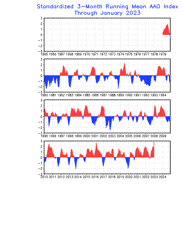
The AAO has been mainly positive for many years.
2015 to now has been exceptional( looking at the time series data below.)
I am currently loosely testing a theory that positive AAO and large ballooning highs coincide.
I have noted that the speed of the high pressure belt is slower in a pos AAO and so gives rise to increased blocking events.
The blocking event of nov 2018 to March 2019 was all pos AAO
The high pressure cells balloon possibly because the ‘drag’ on air parcels is reduced with a slower flow
A slower high pressure belt gives rise also to less frequent troughing.