This post was created to publish any information about JETSTREAMS
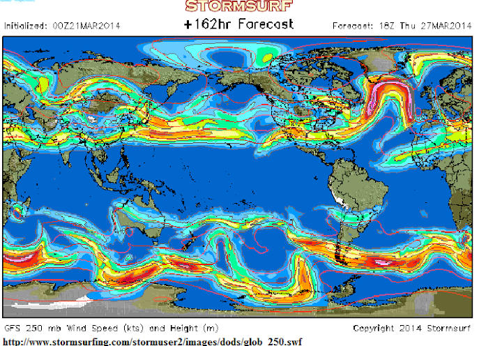
The link below is for the animation which is MUCH BETTER than the still snap above. Go to the link and enjoy the jetstreams in action
source
http://www.stormsurfing.com/stormuser2/images/dods/glob_250.swf
Thanks to GAIL COMBS for posting this link on this fabulous Jetstream animation

A picture of the global jet streams at 200hpa taken on the 21st May 2014
The jet streams strengthen in the winter
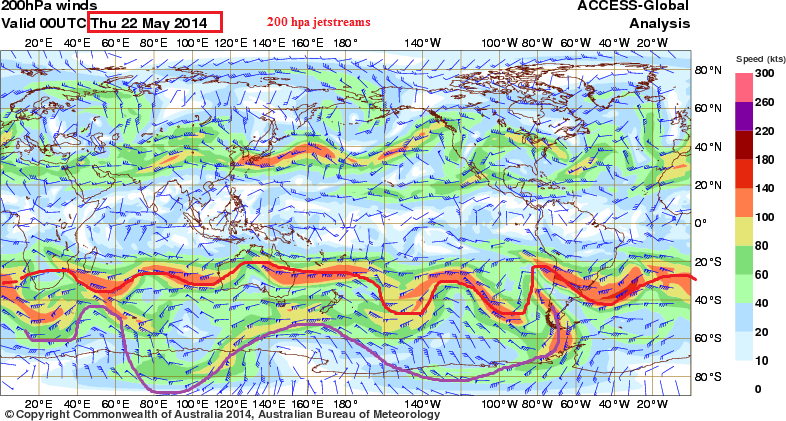
Notice how the SH Jet streams are stronger than the NH curently because we are approaching winter here in Australia
Of interest here also is the strong sub tropical jet BUT a very weak sub polar jet which is required for strong cold fronts to push on to the Australian mainland
The westerly surface low pressure belt also contracted south
source
http://www.bom.gov.au/australia/charts/viewer/index.shtml?type=windbarb&level=200hPa&tz=AEDT&area=G&model=G&chartSubmit=Refresh+View
my collection of jetstreams pics’ here
https://picasaweb.google.com/110600540172511797362/Jetstream2014#6016168313781056114
Southern Hemisphere Jetstream very zonal ( not wavy)
Here on the 3rd June 2014 the sub polar jet is almost non-existent
source
http://www.bom.gov.au/australia/charts/viewer/index.shtml?type=windbarb&level=200hPa&tz=AEDT&area=G&model=G&chartSubmit=Refresh+View
AUGUST 2014
Piers Corybyn forecast re: Jetstream behaviour
http://www.express.co.uk/news/nature/493781/SHOCK-WEATHER-FORECAST-Hottest-August-in-300-YEARS-on-way-as-jet-stream-BOILS-Britain
“Piers Corbyn, forecaster for WeatherAction, said a colossal swathe of roasting air is poised to flood in from Spain and the Sahara Desert.
He said: “This is due to the jet stream which is going to stay unusually elongated keeping high pressure to the east.
“We are going to get a steady flow of air from Spain, Africa and the Sahara with the extreme heat also triggering some thunder storms.
“It is going to be mostly sunny and very pleasant and we could even beat the record high for August of 101.3F (38.5C) set in 2003.
“We are definitely looking at what could turn out to be the hottest August on record after a cooler start to the month.”
“
Some thought provoking comments by Steven Wilde ,JAMIE and Geoff Sharpe
on the Jetstream behaviour
Stephen Wilde says
“I think I’m pretty close with the concept of solar effects on ozone in the stratosphere changing the gradient of tropopause height between equator and poles so as to alter jet stream behaviour between zonality and meridionality to change global albedo which influences the proportion of solar energy getting into the oceans.
There might well be additional detail to fit into that overall scenario but I cannot see any reasonable alternative to that general overview.
Having been drawing attention to the jet stream aspect since 2007 I’m pleased to see it coming to the fore”.
AND
Geoff says
“The jet stream bends because of the greater occurrence of low pressure systems which are equally backed up by intense high pressure systems. The speed of the jet stream is also enhanced by this phenomenon.
So far with the current Australian winter we are seeing an even greater occurrence of strong low pressure systems.
The upcoming NH winter will probably be more brutal than experienced over recent years if this trend continues. Those in the UK should prepare for their share this time around.
http://www.landscheidt.info/?q=node/331
”
AND
JAMIE
“There is huge confusion generally around the topic of the ‘polar vortex’ and the ‘jet stream’. What we regard as the ‘jet stream’ which is largely responsible for our patterns of weather is in fact more correctly described as the polar front jet stream, driven by the temperature gradient between Arctic and subtropical air masses, typically at a height of 10km.
Strictly speaking, the Polar Vortex is the low ozone cell of very cold, ozone depleted air which forms above the North or South Pole during winter when sunlight is absent. The much higher Polar Night Jet circles this vortex, which breaks down in spring, along with the Polar Night Jet, returning during winter. The Americans describe the ‘polar vortex’ as the lower altitude winter phenomenon caused by the polar front (and hence the polar front jet stream) diverting far south over the continental mass, allowing much colder air to dominate.
But the confusion doesn’t end there. This summer, we heard about the ‘polar vortex’ being responsible for much cooler temperatures over Eastern and Central US. But it wasn’t strictly a ‘polar vortex’ because that is a winter phenomenon associated with the Polar Vortex air mass which does not exist in summer! Colder air most certainly does prevail over the pole, even in summer, and it is this air which penetrated further south than normal, along with the mid-latitude, lower altitude polar front jet stream – the ‘jet stream’.
http://www.livescience.com/46795-summer-polar-vortex.html
http://www.accuweather.com/en/weather-news/midwest-to-feel-septemberlike/30357926
It seems to me that current scientific understanding of the various jet streams which encircle our planet at differing altitudes is far from perfect and this appears to be the source of the confusion surrounding the subject of polar vortices, ‘jet streams’, planetary waves/Rossby waves etc in general. It’s actually very difficult to find information on the relationship between the Polar Night JS and the polar front JS and how they affect our winter weather, plus the subtle difference between the effect of the polar front jet stream during summer and the same jet during winter, when the Polar Vortex proper exists. It is therefore probably no surprise that the complex set of interactions these jets have with internal and external climate/weather forcings (e.g. solar, lunar, AMO, PDO) is also imperfectly understood; thus predictions of weather based upon them are never going to be infallible. Perhaps they never will be, if chaos theory has anything to do with it. Perhaps we will never be in a position to accurately predict weather in the short term, medium term or even very long term (climate), simply because of the inherently chaotic nature of our planet’s coupled oceanic/atmospheric dynamic system.
”
Discussed here
July 19th 2014
A good case study here of jet stream meanders and an anomalous cold pool bringing some COLD RECORDS to parts of the US
Autumnlike Chill Sets More Records in Central US, South
———————————————————
http://www.accuweather.com/en/weather-news/midwest-to-feel-septemberlike/30357926
“Daytime temperatures on Thursday in parts of Kansas, Oklahoma and Arkansas failed to rise out of the 60s due to the combination of thick cloud cover and occasional rain.
The high temperature Thursday in Wichita, Kansas, was only 67 degrees, which is 26 degrees below average for the middle of July. To add more perspective, 67 is their average high temperature for the latter part of October.
Earlier in the week, temperatures failed to climb past the 60s F from the eastern part of the Dakotas, through Minnesota, northern Wisconsin and the Upper Peninsula of Michigan on Monday.
Minneapolis, home of the 2014 Major League Baseball All-Star Game, set a record low maximum temperature of 65 on Monday, breaking the old record of 68 set in 1884.
Nearly a dozen cities across the Plains set or tied record lows Tuesday morning including Omaha, Nebraska; Kansas City, Missouri; Rapid City, South Dakota; and Dodge City, Kansas.
The polar air continued to expand southward over the Plains, eastward across the Midwest and touched the interior South and Appalachians Wednesday and Thursday.
During Wednesday morning, record low temperatures in the books since the 1800s were challenged at Nashville and Oklahoma City. At Nashville, the record of 57 F, set in 1886 was tied.
High temperatures on Wednesday ranged from the upper 60s to the lower 70s from Chicago and Milwaukee to Detroit, Indianapolis and Cleveland.
Dozens of cities over the Midwest challenged record low temperature through Thursday morning. Fort Wayne, Ind., dipped to 48 degrees early Thursday, breaking the old record of 51 set in 1976.
Early Friday morning, the chilliest temperatures were found across parts of Ohio, West Virginia, Pennsylvania and New York state, where temperatures dipped into the 40s in some locations.
The temperature at Charlotte, North Carolina, came within 1 degree of tying the record of 62 degrees set in 1896 on Friday.”
A nice shot of Jetstream action taken by GEOFF SHARPE of the 250hpa
Showing some nice wavy sub polar jet action and strong zonal sub polar action
This event the first weekAugust 2014 brought low level snow and cold temps’ to south east Victoria in Australia
Geoffs blog link
http://www.landscheidt.info/?q=node/331
Image by nullschool

5th April 2015
Jetstream pattern for the southern hemisphere
SOURCE
http://www.bom.gov.au/australia/charts/viewer/index.shtml?type=windbarb&level=200hPa&tz=AEDT&area=SH&model=G&chartSubmit=Refresh+View
Southern hemisphere
30th June 2015
A weak sub polar jet in conjunction with low amounts of snow on the Australian alps
and a strong sub tropical jet with a southern anomaly
A great link here for southern hemisphere jetstream information
http://www.micklehamweather.com/wxjetstream.php
Why is jet stream so far south?
In the winter the polar jet moves south and becomes stronger because the North Pole gets colder but the equator stays about the same temperature. This increases the temperature contrast and moves the strengthened polar front jet farther south.
https://climate.ncsu.edu/edu/JetStream
…..
Hi ‘stratobendigo’.
Thanks for joining the conversation
Firstly.,Trying to find information about jetstreams in the SH is very hard .Its always the NH that is mostly found in the literature.
I would expect the dynamics are somewhat similar, except we have a vast expanse of sea in the SH and l believe it makes our jets less prone to massive waves like they get in the NH from temp land and ocean contrasts.
That makes you comment regarding sea surface temps’ more intriguing. Surely the ocean temps have a significant role
One quote from credible source
‘Why is jet stream so far south?
In the winter the polar jet moves south and becomes stronger because the North Pole gets colder but the equator stays about the same temperature. This increases the temperature contrast and moves the strengthened polar front jet farther south.
https://climate.ncsu.edu/edu/JetStream
From that comment one assumes that the jets being south for winter is a regular event.
Just a point of interest.20th July 2019today.
Today surface temp’ gradient from the sth pole to melbourne (using ACC G model)
SOUTH POLE -60DEG C ….10am
melbourne about 10deg c
Temp gradient difference 70deg c
….
Melbourne to the equator
Melbourne 10deg c
Equator at similar longitude 28deg c
temp gradient difference =18deg c
Pole to equator temp’ difference -60 …..+28 = 88 deg c
and so we can look at that temp’ gradient this summer and see the difference in position of sub tropical jet , l suppose
..
taken from discussion on Australian Weather forum
http://www.theaustralianweatherforum.com/forum/viewtopic.php?f=3&t=2469&p=111440#p111440
Possible record jetstream for summer,2019
https://www.theweathernetwork.com/ca/news/article/western-canada-record-jet-stream-for-middle-of-july-and-the-snowy-consequences-cold-upper-trough
Astonishing winter-like jet stream threatens two provinces with July SNOW
Tyler Hamilton
Meteorologist
Thursday, July 18th 2019, 10:36 am – This is a jet stream for the record books and its consequences are…snowy!
pilots forum
https://www.theairlinepilots.com/forum/viewtopic.php?f=22&t=275
Post by K.Haroon » Sat Jun 04, 2011 8:13 pm
Jet Stream and Polar Front
Jet streams are fast flowing, narrow air currents found in the atmospheres of some planets, including Earth. The main jet streams are located near the tropopause. The major jet streams on Earth are westerly winds (flowing west to east). Their paths typically have a meandering shape; jet streams may start, stop, split into two or more parts, combine into one stream, or flow in various directions including the opposite direction of most of the jet. The strongest jet streams are the polar jets, at around 7–12 km (23,000–39,000 ft) above sea level, and the higher and somewhat weaker subtropical jets at around 10–16 km (33,000–52,000 ft). The northern hemisphere and the southern hemisphere each have both a polar jet and a subtropical jet. The northern hemisphere polar jet flows over the middle to northern latitudes of North America, Europe, and Asia and their intervening oceans, while the southern hemisphere polar jet mostly circles Antarctica all year round.
Jet streams are caused by a combination of a planet’s rotation on its axis and atmospheric heating (by solar radiation and, on some planets other than Earth, internal heat). The Coriolis effect describes how a planet’s surface and atmosphere rotate fastest at the planet’s equator while virtually not rotating at all at the poles. Jet streams form near boundaries of adjacent air masses with significant differences in temperature, such as the polar region and the warmer air towards the equator.
Flight time can be dramatically affected by either flying with the flow or against the flow of a jet stream. Clear-air turbulence, a potential hazard to aircraft passenger safety, often is found in a jet stream’s vicinity.
Polar jet streams are typically located near the 250 hPa pressure level, or 7 kilometres (4.3 mi) to 12 kilometres (7.5 mi) above sea level, while the weaker subtropical jet streams are much higher, between 10 kilometres (6.2 mi) and 16 kilometres (9.9 mi) above sea level. In each hemisphere, both upper-level jet streams form near breaks in the tropopause, which is at a higher altitude near the equator than it is over the poles, with large changes in its height occurring near the location of the jet stream. The northern hemisphere polar jet stream is most commonly found between latitudes 30°N and 60°N, while the northern subtropical jet stream located close to latitude 30°N. The upper level jet stream is said to “follow the sun” as it moves northward during the warm season, or late spring and summer, and southward during the cold season, or autumn and winter.
The width of a jet stream is typically a few hundred miles and its vertical thickness often less than three miles.
The wind speeds vary according to the temperature gradient, exceeding 92 kilometres per hour (50 kn), although speeds of over 398 kilometres per hour (215 kn) have been measured. Meteorologists now understand that the path of jet streams steers cyclonic storm systems at lower levels in the atmosphere, and so knowledge of their course has become an important part of weather forecasting. For example, in 2007, Britain experienced severe flooding as a result of the polar jet staying south for the summer.
The polar and subtropical jets merge at some locations and times, while at other times they are well separated.
Associated with jet streams is a phenomenon known as clear air turbulence (CAT), caused by vertical and horizontal windshear connected to the jet streams.
The CAT is strongest on the cold air side of the jet, next to and just underneath the axis of the jet.
There are two factors which create CAT – a rapid change of wind speed and a rapid change of wind direction. A curved jet steam provides both factors. Furthermore, an associated ‘deep trough’ implies that there is a strong pressure gradient which also increases wind speed.
Source:
(http://en.wikipedia.org/wiki/Jet_stream)
(http://www.atpforum.eu/showthread.php?p=34664)
Last edited by K.Haroon on Tue Jun 28, 2011 6:04 am, edited 7 times in total.
This is probably the best description of jetstream behavior and explanation l have come across.
http://www.islandnet.com/~see/weather/elements/jetstream2.htm
Record Jetstream speeds
Extract
It appears that’s a record for the Boeing 787-9 twin jet, which in the past has flown at speeds up to 776 mph. The ordinary cruising speed of a Dreamliner is 561 mph, with a maximum propulsion of 587 mph.Feb 19, 2019
The jet stream, the high-altitude air current along which storms travel, is furious. The river of air was clocked at more than 230 mph over Long Island on Monday. That measure comes from the 250 millibar pressure level, meaning it was at a height above 75 percent of the atmosphere’s mass. It sets the record for the fastest 250 millibar wind speed ever recorded over New York and, probably, the country.
source
https://www.washingtonpost.com/weather/2019/02/19/flight-reaches-mph-furious-jet-stream-packs-record-breaking-speeds/?noredirect=on&utm_term=.2ae9faa59edf
The Speed of the Polar Jet Stream varies depending on the time of the year. When it is winter in the Northern hemisphere it can reach up to 300 miles an hour but it has been measured at a speed of 400 miles an hour in southwest Scotland.
by K Haroon
https://www.theairlinepilots.com/forum/viewtopic.php?f=22&t=275#p427
.
Link to 200hpa wind streams by nullschool, showing the jetstreams in the SH.
https://earth.nullschool.net/#current/wind/isobaric/250hPa/orthographic=-221.33,-61.79,488/loc=98.996,-57.115
The southern hemisphere jetstream pattern has changed from zonal sub tropical and weak sub polar in the winter of 2019 to a moderate meridonal wavy pattern for both jets. The sub polar jet still looks a bit weak
http://www.bom.gov.au/australia/charts/viewer/index.shtml?type=windbarb&level=200hPa&tz=AEDT&area=SH&model=G&chartSubmit=Refresh+View