This is an on-going observation of southern cold fronts over the Australian mainland for 2014..
SCROLL DOWN TO THE COMMENTS FOR POSTS
If the comments don’t load . Click on the Title of this post and that will load the latest updates and comments…
cheers

image : Thanks to http://0.tqn.com/d/weather/

Massive cold front March 2014.. VIC..SA..NSW..QLD.. TAS.. NZ
the windstream pattern is humongous effecting the eastern half of Australia ( SA, VIC, NSW, QLD, Tasmania )and New Zealand
Arriving from the depths of the southern ocean
I suspect the jetstreams are ramping up into a meridonal wavy pattern
——-
ACCESS downgraded this event. The cold front did not bring snow to Tassie or the OZ mainland
Next!
The Jetstream is tending meridonal /wavy currently.
Increases chances of severe weather,and range of temps( hot then cold )
Importantly the sub polar jet is wavy/meridonal so it can bring cold air up from the southern ocean
Where the sub tropical jet meets the sub polar jet. You can get severe storms like the NSW event today
Here is the global 200 hPa ( stratosphere/ upper layer)
You can see the jetstreaks
the sub tropical and sub polar
THe sub polar jet active is important for snow
I think Tassie has 532 thickness later this week
RESULTS FOR 16th March 2014
Indicating a cold front dropping temperatures below the mean for March for the south eastern sector of Australia
source
http://www.bom.gov.au/jsp/awap/temp/index.jsp?colour=colour&time=latest&step=0&map=maxanom&period=daily&area=nat
Lowest temp for Mt wellington for the cold front 1.9 deg c overnight
Hobart airport lowest temp’= 10.4 DEG C AT 2.30am overnight
998.4 hpa = LOWEST mslp
Melbourne airport 12.2 deg c 9.30pm on the 16th March 2014
Ballarat 7.3 deg c on the 16th March 6.30am
Mt Buller 0.7 deg c at 3.30pm 16th March with 2mm of precipitation. SLUSH
Canberra 7.7 deg c 6.30am 17th /3
Thredbo -0.1 deg c 7pm on the 16th /3 with likely 2mm of slushy precip
Thredbo top station (1957m) ..had temps around zero for about 5hrs from the cold front 16th/17th March with 2mm of precip. Maybe some slush fell from the sky
Gust of 137 km/hr with a westerly wind change
http://www.bom.gov.au/products/IDN60801/IDN60801.95909.shtml
source
http://www.bom.gov.au/tas/observations/tasall.shtml?ref=hdr
cold front passing through tomorrow down south.21st march 2014.
It is dropping south east and the 544 thickness line just scrapes west Tasmania
Just noting this..
The 544 thickness line has been shy to come near the OZ mainland so far this Autumn
ACCESS G has a glimpse this week with the 54 thickness line crossing Tasmania 3 days this week
Friday the 18th April 2014…and the 20th and 21st
source
http://www.bom.gov.au/australia/charts/viewer/index.shtml?type=mslp-thick&tz=AEDT&area=Au&model=CG&chartSubmit=Refresh+View
Canberra was 4 deg c this morning so you don’t need cold fronts for lower temps
A beauty cold front coming through currently in the south east quadrant. The alps recording 53cm ( half a metre in 24 hrs) at perisher weather station. More forecast
Not bad considering the sub- polar jet is not to be seen
Severe weather warnings for the south east . High winds from this system
Falls creek table meter

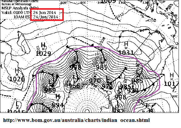
24TH June 2014 SNOW EVENT : SYNOPTIC
http://www.bom.gov.au/australia/charts/viewer/
23rd JUNE 2014
Snowing in Adaminaby ( 1000m)
Cabramurra at 1482m has been below zero for the past 24 hrs and likely 8cm of snow 23rd June 2014
Mt Ginini (1760m)currently -4 deg and has been below zero for the past 30 hrs. Likely 18cm of snow .
ACCESS has a deep and wide incursion of cold ( 544 thickness)over NSW up to the QLD border next weekend (~29th June 2014)
Looks broader in extent covering a wider area.
http://www.bom.gov.au/australia/charts/v…it=Refresh+View
Thanks to Ken Kato for snapping this picture of closed cold pool low near VIC
NICE! and the weatherzone thread following this event
http://forum.weatherzone.com.au/ubbthreads.php/topics/1267301/Re_Strong_fronts_over_multiple#Post1267301
HIGH WINDS for this event
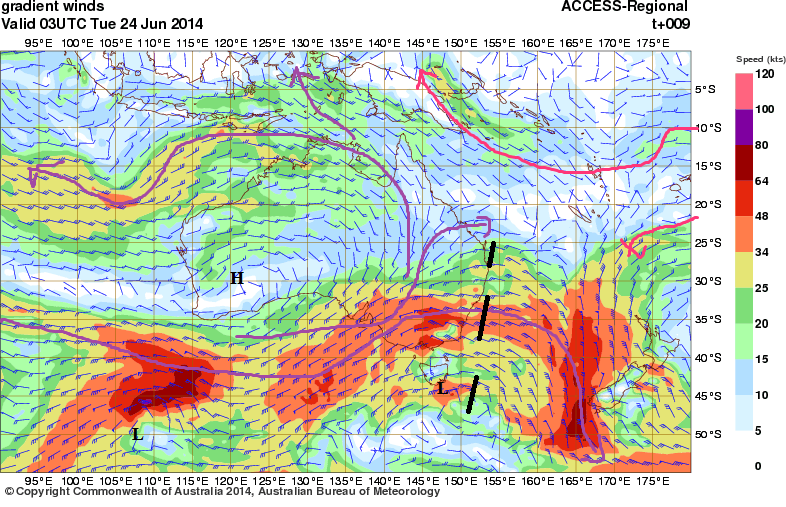
100km/hr gust 1pm Melbourne airport and windy across the state
MSLP 994 hpa at 10.30am
http://www.bom.gov.au/vic/observations/vicall.shtml
—————–
Gradient winds 1km altitude
————
SAM is currently positive atm.
From what l have noted in the past, strong swings in either direction get a bit of wave action happening and there was a strong swing in the first fortnight of June from neg’ to pos’
http://www.cpc.ncep.noaa.gov/products/precip/CWlink/ENSO/verf/new.aao.shtml
I also noted 3 strong lows in the SH antartic region earlier this week that may have to have played a role in some action of an expanded westerly belt
Westerly belt has swollen since the first week of June as it should for winter
and it must hold some nice cold air l assume. Here in this MSLP map VIC is being clipped by the westerly low pressure belt
Sub tropical jet is very strong currently . THe sub polar jet starting to shows slight signs of strengthening in the sub polar region atm
http://www.news.com.au/travel/travel-ideas/best-snowfalls-in-a-decade-forecast-for-eastern-australia-strap-yourselves-in-for-the-megablizzard/story-e6frfqdr-1226963855196
Record snow falls at perisher NSW for that last system being touted by the news?
Tue 24/06/2014 -5.0 – -0.3 – 54.0 cm
Wed 25/06/2014 -4.1 – 0 – 49.4cm
201mm of precipitation so far this month of June 2014!!
http://www.weatherzone.com.au/station.jsp?lt=site&lc=71075&list=ds
picture gallery
http://www.canberratimes.com.au/photogallery/act-news/snowfall-at-thredbo-and-perisher-20130624-2orzx.html
—————
An awesome cold front forecast for the end of June as seen on this MSLP
Look at the length of that cold front
https://picasaweb.google.com/110600540172511797362/MSLP#6028764208238013538
ACCESS has a low emerging south of south WA and traverses east across the Bight and Tasmania . The troughing is extensive and is extensive up into the QLD border
The MSLP is expected as low as 980hpa south of Adelaide on Friday afternoon
So this system has a decent V8 motor and should drive some strong s/westerlies well up into the eastern quadrant of Australia.
Good snow falls for the alps once again Saturday and sunday (28-29th June 2014)
As a side note .Notice the sub tropical low of the WA coast .
http://www.bom.gov.au/australia/charts/viewer/index.shtml
ACCESS indicating the extensive area of the cold pool over VIC, NSW, TASMANIA, SA AND STH QLD. ( 544 THICKNESS COLD POOL)
for 2 days! Saturday 28th and Sunday 29thy June 2014
The 532 line covers Tasmania on Sunday night
MID LAYER for the 28th/29th June event
Strong mid layer troughing supporting the surface troughing ,with a deep fetch from the southern sub – antartcic region
http://www.bom.gov.au/australia/charts/viewer/index.shtml?type=windbarb&level=500hPa&tz=AEDT&area=Au&model=CG&chartSubmit=Refresh+View
10th July 2014
Another foot od snow to ad to the 2m the other week and some snow at Oberon today
https://picasaweb.google.com/110600540172511797362/COLDFRONTSAustralia2014#6034336489175581554
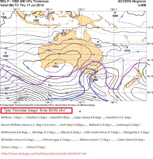
The best cold front forecast by ACCESS this week is for the 17th July 2014
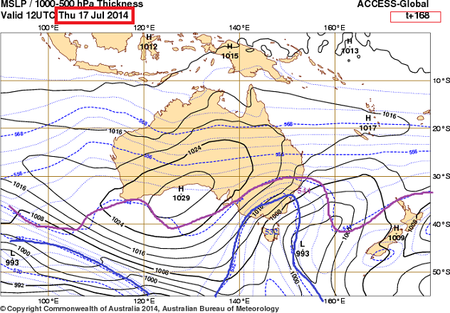
The 532 thickness line extends over Tasmania southern Vic and the VIC and NSW alps
Looking to be a great cold/snow event
http://www.bom.gov.au/australia/charts/viewer/
ACCESS has done an outstanding job forecasting this event 7 days out

Ha.. Found an even better one. Here is ACCESS at T+168 hrs 168/24= 7 days!!) compared to the target date.
This is some freaky match !!
KUDOS to the developers !!
T + 168 hrs
and today the target date
Interesting to see the warmer temps on the coastline in this 532 thickness pool.
————————
That 532 cold pool is forecast to be cut off over parts of VIC and NSW overnight…Any precip’ will bring snow overnight one would think
Be interesting to check the obs for overnight
Looking nice and chilly down south. The 532 thickness line is pushing in across Victoria and will push in to NSW tonight
143 km /hr gust Maaksukyer island on the west coast of Tassie today
Some strong gusts expected in the south east of OZ in the next 24 hrs
30th JUly 2014 -3rd August
Heads up for a possible deep inland penetration of a cold pool 532 thicknesss
Thanks to ken kato
http://forum.weatherzone.com.au/ubbthreads.php/topics/1270860/2
Here is ACCESS at the commencement of the event
http://www.bom.gov.au/australia/charts/viewer/index.shtml?type=mslp-thick&tz=AEDT&area=Au&model=CG&chartSubmit=Refresh+View
30th July 2014
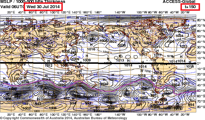
http://www.bom.gov.au/australia/charts/viewer/index.shtml?type=mslp-thick&tz=AEDT&area=G&model=G&chartSubmit=Refresh+View
2nd AUGUST 2014
Nice cold pool arriving. A decent rainband ahead of the cold front and good chances of low level snow for VICTORIA and south eastern NSW
Should be a good event for the Alps and snow industry
The event moves quite quickly commencing Thursday about 4pm 1st august and deepens into Friday with the 532 thickness line encompassing a broad area
The temps should plummet quickly and the cold pool. is over the area for 24hrs and moves away by Friday evening.
This could be the best so far of the season
Friday evening the 1st August is the peak of this spectacular cold pool
Parts of Tasmania down to 524 thickness!! Awesome ..
532 thickness over a broad swathe of the South east
544 up to the QLD border at 30 deg S
34-48 knot ( 68-96km/hr) sustained winds on the SA and VIC coastline
Tie down the trampolines and stay inside in a secure home event
Very nasty!
These are surface wind speeds and do not include potential gusts!!
Check BOM warnings!
http://www.bom.gov.au/australia/warnings/index.shtml
http://www.bom.gov.au/australia/charts/viewer/index.shtml?type=windbarb&level=10m&tz=AEDT&area=Au&model=CG&chartSubmit=Refresh+View
ACCESS is forecasting a cold front and cold pool over VIC and Tasmania for the first day of spring 1st sept 2014
The last one of any significance for VIC/NSW was a month ago on the 1st AUG 2014. The rest of the month was quiet with very large deep high pressure systems giving SA some record minima and frosts
http://www.bom.gov.au/australia/charts/viewer/