CYCLONES_____HURRICANES______TYPHOONS
>>>>>> Scroll down to last post for the latest update
- GLOBAL SATELLITE PICTURE 16th AUGUST 2013
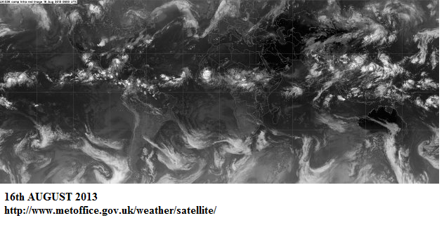
I try to look at the global satellite picture from MET OFFICE most days.
I noticed yesterday that suddenly the cloudy ITCZ ( Inter-tropical convergence zone) became coalesced.!!
By that l mean the entire convergence zone became a mass of cloudy spots or tropical lows.
These lows often spawn Hurricanes or Typhoons
Things have been quiet relatively in the Northern hemisphere up until now.
Intriguing as to why the coalescence of cloud into points of tropical lows happened so suddenly?
I suspect the wind streams that support the ITCZ have strengthened?
however other ideas would be welcome .
The coalescence has occurred right acros the board and not just in one equatorial ocean basin
I have noted this by taking a snap.. and will note which of these lows on and near the ITCZ wil make it into cyclone categories as the days go by
http://www.metoffice.gov.uk/weather/satellite/
—————————————————
Came across WIKOPEDIA’s outstanding up to date inventory of the 2013 Northern hemisphere cyclone season
This is outstanding.
Someone is updating this almost daily
Get the LATEST and ongoing historical documentation of this season
updated almost DAILY !! CHECK these links out
and you will bookmark
here
- ATLANTIC
http://en.wikipedia.org/wiki/2013_Atlantic_hurricane_season
and
- PACIFIC
http://en.wikipedia.org/wiki/2013_Pacific_hurricane_season
and here
- NTH INDIAN OCEAN
http://en.wikipedia.org/wiki/2013_North_Indian_Ocean_cyclone_season
____________________________________________________________________________________
Japan Meteorology Agency : Tropical cyclone Information
HONG KONG Meteorology. TROPICAL CYCLONE WARNINGS
http://www.hko.gov.hk/wxinfo/currwx/tc.htm?20131101143449
HOME
http://www.hko.gov.hk/contente.htm


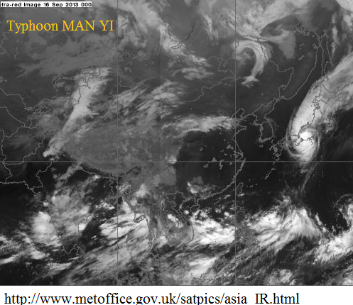
17th September 2013
ACCESS G forecasting a typhoon skim the coast of Japan before heading north east up the coast and transitioning into a monster strong mid altitude low.
Here is ACCESS .I have marked the path in purple and you can see the intensification in the transition
An excellent forum thread on the west pacific Typhoons
http://forum.netweather.tv/tags/forums/west%2Bpacific/
Extract from this forum thread
Man-Yi is expected to peak at minimal typhoon intensity on approach to Japan possible landfall on Monday 17th September 2013
..
This trough is a rather potent one and is being forced south by a intense migratory high that is event causing below freezing temperatures across Mongolia and North East China. This trough will act as a fish hook on Man-yi pulling it quickly north along the pacific coast of Honshu. A landfall is still possible south of Tokyo though. If one was to occur at this time it would seem most likely to be around the Honto Pennisula or Chiba Prefecture during the morning hours on Monday. I would say just prior to the morning rush hour but thankfully this storm will be skirting the coast on a Japanese Holiday. Many business will be closed any ways ahead of the storm.
Tropical Storm Man-Yi
TRACK for Man Yi
Western pacific weather
http://www.westernpacificweather.com/
A nice snap of tropical storm/ typhoon Man YI intensifying . Some well defined wrapping of cloud underway incorporating quite a wide diameter
source
http://www.metoffice.gov.uk/satpics/asia_IR.html
Looks like Man Yi made a landfall at Japan .
Typhoon Man-yi hits Japan raising fears about Fukushima nuclear plant
http://www.abc.net.au/news/2013-09-16/typhoon-man-yi-hits-japan2c-raising-fukushima-fears/4960034
A REPORT from Japan regarding Man Yi landfall
http://www.abc.net.au/news/2013-09-17/an-fukushima-operator-releases-water-into-pacific-as-typhoon-hi/4961820
Typhoon Man-yi has hit Japan, leaving three people dead and forcing the operator of the crippled Fukushima nuclear plant to release rainwater with low levels of radiation into the Pacific Ocean.
The powerful typhoon made landfall in Toyohashi, Aichi prefecture, on Sunday, packing gusts of up to 162 kilometres an hour, the Japan Meteorological Agency said.
Public broadcaster NHK said a 71-year-old woman was found dead as a landslide engulfed her house in Shiga prefecture, while a 77-year-old woman was also confirmed dead in a separate mudslide in Fukui prefecture, near Shiga.
Japanese news agency Jiji Press said a third person, a man aged 63, died after falling from a ladder he climbed to shut a window.
Kyodo news agency, citing local officials, said five people were still missing, while NHK said 128 others were injured with more than 4,000 houses flooded and at least 270 houses damaged by strong wind or landslides.
The typhoon, losing strength slightly, left Japan’s main island by Monday evening after the eye of the storm passed within 50 kilometres north of the capital at around noon
The typhoon also hit the northeast, including the Fukushima area, bringing heavy rain to areas near the broken plant run by Tokyo Electric Power (TEPCO).
——————————————-
VIDEO
http://rt.com/news/japan-typhoon-fukushima-plant-914/
TROPICAL STORM USAGI 18th SEPT 2013
Quite evident on the global satellite picture
source
http://www.metoffice.gov.uk/satpics/asia_IR.html
TRACK
Heading close to Taiwan currently
source
Japanese Meteorological society
http://www.jma.go.jp/en/typh/1319.html
—————————————-
NEWS article
Tropical storm USAGI is forecast to strike Taiwan as a typhoon at about 06:00 GMT on 21 September
http://www.trust.org/item/20130917091302-s5slg/?source=hppartner
Last month, the U.S. National Oceanic and Atmospheric Administration charted the 11,967 tropical cyclones that have occurred on Earth since records began
Read more: http://www.dailymail.co.uk/sciencetech/article-2422486/A-rare-moment-calm-Earth-Stunning-satellite-image-reveals-strangely-clear-skies-Atlantic-Pacific-Indian-Ocean.html#ixzz2fF36Rdt0
Some talk of SUPER TYPHOON USAGI direct or very near landfall on HONG KONG
source file
http://www.typhoon2000.ph/multi/?name=USAGI
Fabulous image of USAGI
source of picture and an excellent report of latest information
http://www.washingtonpost.com/blogs/capital-weather-gang/wp/2013/09/19/super-typhoon-usagi-strongest-storm-of-2013-may-strike-hong-kong-sunday/
MET OFFICE satellite picture 20th Sept 2013
source
http://www.metoffice.gov.uk/satpics/asia_IR.html
Here is a fabulous web site by
MARK VOGAN
Mark reports on major global weather events with some fabulous pictures
The Mark Vogan home page
http://www.markvoganweather.com/
Here is an example of his excellent reports and documentaries on Typhoon OSAGI
http://www.markvoganweather.com/2013/09/20/super-typhoon-usagi-eyes-hong-kong-another-may-eye-japan-antarctic-sea-ice-hits-record-high/
PICTURE Super typhoon OSAGI
LANDFALL near HONG KONG expected 150 knot storm
Outstanding analysis of Typhoon USAGI on you tube by
ROBERT SPETA on facebook
The detail this dude goes into his presentations is mind blowing
The film of landslide.. Get a load of the rock that comes down
and WESTERN PACIFIC WEATHER
USAGI LANDFALL REPORT
http://www.westernpacificweather.com/
Typhoon Usagi was on path to hit on Kong most of the day on Saturday in to Sunday morning, yet by sunday afternoon the unpredictableness of weather showed face and Usagi took an unexpected sharp turn north towards a location half way between Chaouzhou and Hong Kong.
The storms exact location of landfall is near Hudong Harbor in Guangdong. A far less populated area of the china coastline than the Hong Kong Macau Metropolotin area. The storm will bring its full force of sustained winds over 100kts near the coastline in this area yet winds gusting over Typhoon strength is very well possible still in the city of Hong Kong through the over night hours as Usagi tracks inland north of Hong Kong moving right over the Metro area of Guangzhou. The strongest winds will likely be in areas surrounding Victoria Harbor just prior to midnight as Usagi makes its closest approach.
read more
here
http://www.westernpacificweather.com/2013/09/22/typhoon-usagi-makes-landfall-nearly-200km-east-of-hong-kong/
—————————————–
———————————-
You tube chase in TAIWAN
The tropical storm developing behind USAGI has formed into a cyclone and has a name
PABUK
Here is a UK thread following this event
http://forum.netweather.tv/topic/77911-tropical-storm-pabuk/
comment from ‘somerset squall’
Tropical Storm Pabuk has formed, roughly 300 miles southeast of the island of Iwo To, Japan
Video report on Typhoon PABUK.currently CAT 1. Some model uncertainty currently
Linked to
http://www.force.13.com/
under construction
REPORTS EMERGING OF THE DAMAGE AND FATALITIES FROM TYPHOON USAGI
http://www.bbc.co.uk/news/world-asia-24193201
Picture of Typhoon PABUK 26th September 2013
———————————————————————-
source
http://www.metoffice.gov.uk/satpics/asia_IR.html
TYPHOON FITOW 3rd October 2013
The west pacific looks quite active for new cyclogenesis currently
A snap
source
http://www.metoffice.gov.uk/satpics/asia_IR.html
A VERY ACTIVE WEST PACIFIC CURRENTLY..OCTOBER 5th 2013
Picture of FITOW and newly formed DANAS
source

Typhoon DANAS is forecast to head to OKINAWA in JAPAN
Here is a good thread to follow
http://forum.netweather.tv/topic/78030-tropical-storm-danas/
and
http://www.westernpacificweather.com/2013/10/04/tropical-storm-danas-forms-north-of-guam-likely-impact-on-southern-japan/
As of Friday Afternoon Models are in fair agreement of a land falling storm system over Okinawa Honto on Monday Evening.
Danas is the 24th named storm of 2013
TYPHOON FITOW makes landfall in CHINA
…REPORT 7th October
http://www.skynews.com.au/topstories/article.aspx?id=912852&cid=ZBP_NEWS_L_L1-7_TyphoonFitowslamsintoChina_RSS_071013
Typhoon Fitow has barrelled into China’s east coast, packing winds of more than 200 kilometres an hour as hundreds of thousands of people were evacuated and bullet train services suspended, state media report.
…
..The National Meteorological Centre issued a red alert for the storm, which was packing winds of up to 151km/h late on Sunday night as it moved towards the coast.
Winds rose to 201km/h in parts of Wenzhou, the official Xinhua news agency reported later, citing local flood control authorities.
Zhejiang has so far evacuated more than 574,000 people, while in Fujian 177,000 have been displaced, Xinhua said.
Typhoon NARI October 2013
NARI…sliced across the farming region at the centre of the main Philippine island of Luzon before dawn Saturday and later blew out to the South China Sea with peak winds of 120km/h, the state weather service said.
The typhoon also toppled power pylons, blacking out the province of Aurora on the east coast and about half of Tarlac and Zambales provinces, Lontoc said.
http://www.skynews.com.au/topstories/article.aspx?id=914425&cid=ZBP_NEWS_L_L1-9_TyphoonNarileavesmanywithoutpower_RSS_121013
OCTOBER 12th
INDIA…Cyclone Phailin
was packing gusts as high as 240 kilometres per hour and had the potential to be the strongest storm to hit the area in 14 years, bringing a three-metre surge in sea levels.
The US Navy’s Joint Typhoon Centre said gusts could reach as high as 315 kilometres an hour, while London-based Tropical Storm Risk put Phailin in its most severe ‘super cyclone’ category.
The armed forces have been mobilised to help with relief efforts and the Indian Red Cross Society has put disaster response teams on standby in Orissa, Andhra Pradesh and Andaman Nicobar.
Satellite photos showed an intimidating cloud mass barrelling across the Bay of Bengal with forecasters saying the danger zone was about 150 kilometres wide.
Some foreign forecasters have suggested that India’s weather office is underestimating the power of Phailin, however, which means ‘sapphire’ in Thai.
A government report on the 1999 disaster put the death toll at 8243 and said 445,000 livestock perished.
Authorities have said they are better prepared this time around.
Cyclones are a common occurrence in the Bay of Bengal at the end of the steamy monsoon season, when sea temperatures are at their warmest.
A cyclone that struck Bangladesh in 1970 killed hundreds of thousands of people.
source
http://www.skynews.com.au/topstories/article.aspx?id=914482&vId=4186089
Here is a nice snap of triplets in the WEST PACIFIC
Thanks to ‘dawoodman’ from weatherzone forum
http://forum.weatherzone.com.au/ubbthreads.php/topics/1213355/Re_2013_Typhoon_Season_Asia#Post1213355
for this great link for
CYCLONE WATCH
This is a sample link for the coverage of currently developing
typhoon WIPHA
12th oct 2013
http://www.cyclocane.com/wipha-storm-tracker/
Cyclone Phailin..13th OCT 2013
‘We were preparing for a super cyclone, but Phailin did not turn into a super cyclone,’ spokeswoman for the National Disaster Management Authority (NDMA), Tripti Parule, said
The state of Orissa’s top rescue official said 860,000 people moved before the cyclone made landfall on Saturday evening, while at least another 100,000 were evacuated further south in the state of Andhra Pradesh.
In Gopalpur, where the eye of the storm struck,
‘almost 90-95 per cent of people have been evacuated’, he added.
http://www.skynews.com.au/topstories/article.aspx?id=914659&cid=ZBP_NEWS_L_L1-3_Indiasbiggestcycloneevacuation_RSS_131013
TYPHOON WIPHA heading for EAST COAST of JAPAN 16th October 2013
Heavy rain rates expected for TOKYO.
Thanks to Ken Kato for the ‘Heads up’ and track map
Thanks to Ken Kato for this link and information on the impact of Typhoon WIPHA
Some record rainfall on the Island of IZU OSHIMA
Can you imagine 800mm of rain falling in 24 hrs
Typhoon Wipha pounds Japan
source
http://www3.nhk.or.jp/nhkworld/english/news/20131016_17.html
Typhoon Wipha is now bringing heavy rains and strong winds to central and northern Japan. The large and powerful storm killed 7 people on Izu Oshima Island, south of Tokyo. The island had its heaviest rainfall on record.
The Meteorological Agency estimates that as of 11 AM on Wednesday, the typhoon was over the sea southeast of Miyagi Prefecture and was moving north-northeast at 70 kilometers per hour.
It had a central atmospheric pressure reading of 960 hectopascals, and was packing winds of up to 126 kilometers per hour near its center.
Police said the bodies of 5 people were found in areas where homes collapsed or were buried under mud on Izu Oshima Island. The bodies of 2 others were found near the mouth of a swollen river.
Local officials have been unable to contact about 50 other residents.
The rainfall over the past 24 hours on the island has exceeded 800 millimeters. That’s more than double the average for October and the heaviest downpour since data became available.
Police are searching for 2 boys who went missing from a beach in Kanagawa Prefecture, near Tokyo. The 6th-graders were playing when waves swept them away.
The typhoon has flooded homes and caused mudslides in some areas, as well as power outages.
The stormy weather continues to disrupt rail and road traffic.
Oct. 16, 2013 – Updated 02:23 UTC
Another Typhoon heading for Japan in OCTOBER 2013
This one is called
Typhoon FRANCESCO
and has a well defined eye currently on the 18th OCT 2013.
source
http://www.metoffice.gov.uk/satpics/asia_IR.html
ACCESS global is indicating Typhoon Francesco will barrel through the islands of Japan
http://www.bom.gov.au/australia/charts/viewer/index.shtml?type=mslp-precip&tz=AEDT&area=G&model=G&chartSubmit=Refresh+View
Here is an excellent forum thread to update on this typhoon suggesting a landfall on 25ht Oct 2013
http://forum.netweather.tv/topic/78173-super-typhoon-francisco/page-2
Super typhoon Francisco is forecast to strike Japan as a typhoon at about 00:00 GMT on 25 October
.
Super typhoon Francisco is forecast to strike Japan as a typhoon at about 00:00 GMT on 25 October. Data supplied by the US Navy and Air Force Joint Typhoon Warning Center suggest that the point of landfall will be near 33.0 N, 136.6 E. Francisco is expected to bring 1-minute maximum sustained winds to the region of around 157 km/h (97 mph). Wind gusts in the area may be considerably higher.
According to the Saffir-Simpson damage scale the potential property damage and flooding from a storm of Francisco’s strength (category 2) at landfall includes: Storm surge generally 1.8-2.4 metres (6-8 feet) above normal.
——————————————–
There is another typhoon developing behind Francesco.
http://www.metoffice.gov.uk/weather/satellite/
ACCESS G suggests this new development will not follow Francesco to Japan and will remain well put to sea.
The two seem to form a duo on transition northward to mid-latitudes
Thanks to ‘coldfront’ from weatherzone forum for posting thus fabulous snap of the
TYPHOON LEKIMA ..24th October 2013
and the continuing very active west pacific ocean cyclogenesis
http://forum.weatherzone.com.au/ubbthreads.php/topics/1215034/26
Some Tropical storm/ cyclogenesis emerging in the Indian ocean currently
(27th OCT 2013)
However this low/storm is not born from the ITCZ( inter-tropical convergence zone) from a cross equatorial flow.
There is a strong easterly stream at 10 deg S latitude crossing the northern Indian ocean and is rebounding of the coast of Majorca creating a nice rotation/eddy at the surface layer
Might just note that the 200hpa wind direction is also easterly
source
http://www.metoffice.gov.uk/weather/satellite/
TYPHOON KROSA . November week one 2013
Possible threat to Vietnam
source
http://www.metoffice.gov.uk/satpics/asia_IR.html
—————————————————————-
Report from ‘Netweather’ forum
http://forum.netweather.tv/topic/78315-typhoon-krosa/
report by..’summerset squall’
“The twentyninth tropical depression of the 2013 West Pacific typhoon season has formed roughly 700 nautical miles east of Manila, Philippines..
Interaction with Luzon weakened Krosa to 75kts, but the typhoon has ramped up considerably this evening, and is now a 100kt cat 3 on the SS scale. The small eye I noted when Krosa was skirting the north coast of Luzon was disrupted by land but has now been replaced by a much larger eye which has cleared out this evening
Krosa is probably near peak intensity, as shear is higher where Krosa is headed, plus the typhoon is expected to interact with land soon (Hainan Island). However, Krosa is still likely to be a threat to Vietnam in the longer term, the threat being mainly from flooding rains. In the nearer term however, Hainan Island has this to be concerned about with damaging winds also being very likely.
Typhoon HAIYAN
Picture from Bellmereweather
http://www.bellmereweather.net/SatPics-MtSat.asp
ABC report
Typhoon Haiyan gaining strength, heading towards the Philippines
Shivali Nayak, and staff, Wednesday November 6, 2013 – 16:07 EDT
Typhoon Haiyan is intensifying as it continues to move across the northern Pacific, packing winds of up to 240 kilometres per hour.
Michael Ziobrol, from the US National Weather Service, says the typhoon is forecast to affect parts of Micronesia later on Wednesday.
“It’s going pretty quickly and it’s going to go to Palau and south of Yap but there’s a little island there with a few people called Nrulu and they’re probably going to get the eye of the typhoon over them,” he said.
Mr Ziobro says many of the islands in the path of the typhoon are low-lying areas.
“Some of these little islands are not very high… levels above the ocean so some of the wave action would be higher than atolls,” he said.
Haiyan is expected to reach central Philippines as a super typhoon by Friday noon local time, moving at 233-249 kilometres per hour, according to Michael Ziobrol.
The typhoon will be named Yolanda when it enters the Philippines.
The country is hit by some 20 typhoons each year. Typhoon Nari pounded the archipelago’s north last month, killing 13 people.
© ABC 2013
Incredible.. You tube video of typhoon Haiyan
November 8th 2013
from ‘icyclone.com’
http://www.icyclone.com/
Thanks to the author
CycloneJosh
Loc: West Hollywood, California USA
source link
http://forum.weatherzone.com.au/ubbthreads.php/topics/1224230/Re_Super_Typhoon_HAIYAN_YOLAND#Post1224230
8th July 2015
A triplet heading out of the nursery

https://au.news.yahoo.com/world/a/28715149/huge-storm-band-bearing-down-on-china-and-japan/